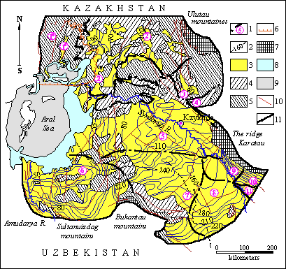
1. State of hydrogeological study of the territory | |
2. Basic aquifers and aquiferous complexes | |
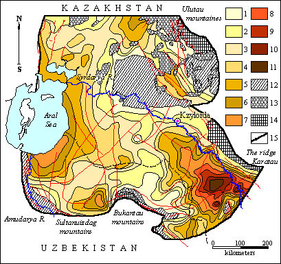
3. Hydrogeological zoning | |
4. Hydrogeological conditions change in the result of technogenic influence | |
Territory of Eastern Priaralye occupies 450 thousand square km. First information about groundwaters of Aral sea basin is connected with the names of D.I.Mushketov, A.S.Fersman, O.K.Lange, I.G.Kassin, A.A.Kozyrev, I.K.Zaitsev, a.o. Systematical investigation of the territory, basically of its Southern and Eastern part, has been undertaken during fifties of the last century. Geological mapping has become the basis of execution of hydrogeological surveying and at the beginning of sixties - of prospecting works. To the end of seventies almost all the territory of Southern-Eastern part of Aral basin was covered with complex geological-hydrogeological surveying of the scale 1: 500 000, 1: 200 000, and considerable part of it - 1: 50 000. For a number of irrigated areas of Kzyl-Ordinskaya, Shymkentskaya provinces of Kazakhstan, and of Karakalpakiya detailed prospecting works with estimation of exploitational reserves of groundwaters were made. First regional hydrogeological investigations dedicated to the problems of formation, regime, hydrodynamics, hydrochemistry and hydrothermistry of groundwaters both for separate regions and also for the whole region of Priaralye belong to this period. These works are connected with the names of U.M.Akh medsafin, Zh.S.Sydykov, N.N. Khodzhibaev, V.I. Dmitrovski, L.A. Ostrovski, I.S. Pashkovski, V.O.Voleisho, A.S. Grebennikov, S.S. Mirzyaev, T.B. Grebenshchikova, N.M. Bondarenko, A.S.Vidnyakov, S.M. Shapiro, V.I.Rubanov, P.V.Volkov, V.V. Krasnikov, I.S.Rusanov, a.o. Each of them has made a definite contribution into the knowledge of hydrogeology of region. U.M. Akhmedsafin has given the description of artesian basins of Kyzyl-Kums, and Northern Priaralye(1961,1968), and together with Zh.S.Sydykov and I.V.Dalyan(1961) - of Easrtern Priaralye groundwaters formation conditions. They have noted that province of regional groundwaters formation are: Eastern slopes of Mugodzhars and Chushkakulskaya anticlines, mountains of Karatau, Talas Alatau, Chatkalski, Karzhantauski and Kuraminski ridge. It has been supposed that basic regional decharge of groundwaters is taking place on the shore and through the bottom of Aral sea.
A considerable body of work of regional character as of the territory of Middle Asia have been made by the scientists from Uzbekistan. Map of natural flows of groundwaters by the territory of Uzbekistan with complex of analytical maps has been prepared. In eighties A.S. Vishnyakov, Kh.R.Duskhodzharv have prepared typization of hydrogeological regions of Middle Asia as the base of execution of hydrogeological forecasting (1988). Numerous works have been made in estimation of natural and exploitational reserves of groundwaters both of regional plan and also in the boundaries of separate parts with further assertion of exploitational resources. Summarized generalizations for Southern - Priaralski artesian basin were prepared by L.A.Ostrovski, (1962,1969, 1973), I.S. Pashkovski(1969), S.Sh.Mirzaev (1964). In them besides mapping of the general regularity of groundwaters formation of Cretaceous depositions, hydrodynamic conditions, strata parametres, are given the results of balance calculations. I.V. Pinkhasov (1984) has characterized the basic stages of relief formation. Abundance of water of basic aquifers and distribution of heads both in area and also in profile are defined, hydrochemical and geothermal zonings are found out in the work of T.B. Grebenshchikova(1976) executed in the limits of Syrdarya artesian basin. Geological-geophysical investigations are generalized by I.M.Melkanovitski (1975). He has indicated the presence of areal dependency among water-bearing complexes, has defined its intensity. But these calculations have not been subjected to balance studies. Beginning from seventies for the study of Priaralye groundwaters, methods of mathematical simulations have come into wide use.
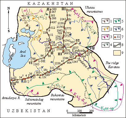
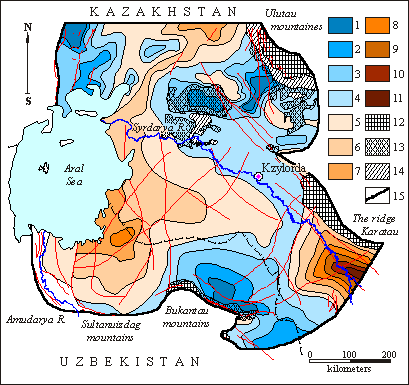
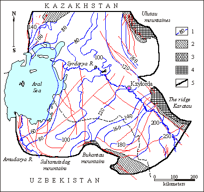
Works with many plans in this direction have been made by Kazakhstanic and Uzbek investigators during last 10-15 years. To them belong the works of V.P. Zolotarev(1990) in simulation of ground and salt flow into the basin of Aral sea, of N.V. Kalmykova in establishment of hydrodynamic model of Syrdarya artesian basin (1989), of S.M. Shapiro, T.N. Vinnikova a.o. in regional investigations of Syrdarya artesian basin groundwaters formation processes on the base of mathematical simulation(1988, 1989, 1991, 1992, 1995), of V.V.Veselov,V.M. Mirlas, V.Yu. Panichkijn a.o. in creation of regional mathematical model of hydrogeological conditions of Kazakhstanic part of Priaralye for the purposes of rational utilization, management of exploitation and groundwaters protection (1991, 1992, 1995). For the estimation of exploitational resources of Kzylzharminski deposit of groundwaters, situated on the territory of the city of Kzyl-Orda, settlement Tasbuget and their surroundings, model-inset map into regional model of Southern-Eastern Priaralye ( V.V. Vesekov, V.M.Mirlas, L.Yu. Trushel 1995) has been creating. Schematic of disposition of mathematical models of hydrogelogical objects of Eastern Priaralye is given on the Figure.
|
Hookup of the distribution of mathematical models of hydrogeological objects in Priaralye
1 - Boundary of the model of Syrdarya artesian basin and Southern part of Turgai artesian basin(authors: V.V.Veselov, V.M.Mirlas, V.Yu.Panichkin a.o.) 2 - Model boundary of Syrdarya artesian basin(authors: S.M. Shapiro, T.N.Vinnikova, N.V.Kalmykova) 3 - Aral sea basin model boundary (authors: S.M.Shapiro, T.N.Vinninkova, V.P.Zolotarev a.o.) 4 - Boundary of the model of Kzylzharminski deposit of groundwaters (authors: V.V.Veselov, V.M.Mirlas, L.Yu.Trushel)
Prognostic regional estimation of exploitational resources of groundwaters of Upper Cretaceous depositions of Southern Priaralye artesian basin with utilization of the methods of mathematical simulation and in connection with the estimation of groundwaters interrelations with Aral sea has been made by A.S. Khasanov, N. Takhirov, A.G. Isanov (1982). Characteristics of hydrogeological conditions of Eastern Priaralye are given by us on the base of the results of these investigations.
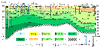
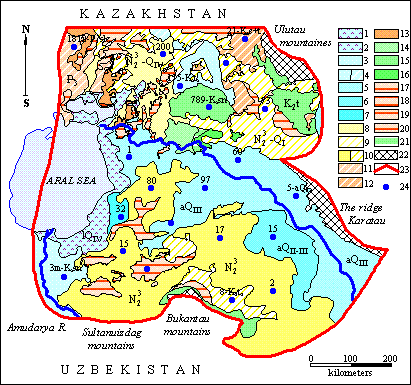
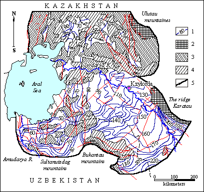
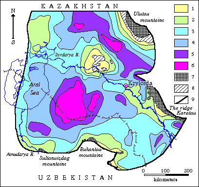
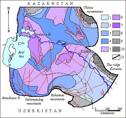
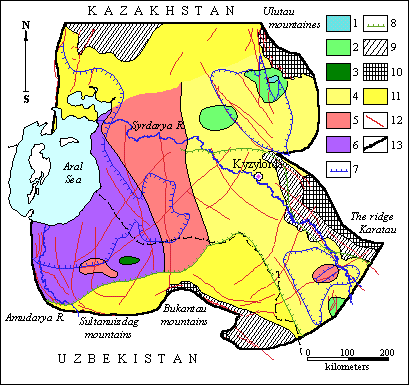
On the investigated territory five main aquifers and aquiferous complexes have been picked which are respectively confined to Neogene-Quaternary, Upper Neocenian, Upper Turonian-Senonian, Upper Albian-Senomanian and Lower-Middle Albian-Jurassic sediments, which distribution areas are illustrated on Figure below. Aquifers and complexes separate three regional waterproof layers, which actually present everywhere, as well as Chegan clays in the North-Western part of the described territory.
Sheme of distribution of basic aquifers and aquiferous complexes Boundaries of distribution of depositions: 1 - Eocenic, 2 -Eocenic-Oligocenic, 3 - Upper Albo-Cenomanian, 4 - Lower-Middle-Albian, 5 - Neocomian- Aptian, 6 - Jurassic, 7 - bore hole and its number, 8 - line of the hydrogeological profile and its number, 9 - investigations region.
|
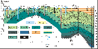
Schematic hydrogeological profile by the line II-II
|
| Schematic hydrogeological profile by the line III-III
|
|
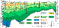
Schematic hydrogeological map |
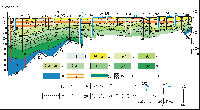
Schematic hydrogeological profile by the line VI-VI
|
| Schematic hydrogeological profile by the line VII-VII
|
Groundwaters expansion: 1 - aquifer of modern lacunar deposition. Clayish sands with interbeds of clays and gypsum; 2 - aquifer of modern marine depositions; 3 - aquifer of modern depositions. Sands, gravels, sandy loams, loams, interlayers of sands among clays; 4 - aquifer of Upper-Quaternary – modern alluvial depositions (a) and sporadically inundated depositions (b). Sands, gravel, sandy loams, loams, interlayers of sands among clays, clays; 5 - aquifer of Upper-Quaternary alluvial depositions. Coarse gravels, gravel-coarse gravels, sands, sandy loams; 6 - aquifer of Middle-Upper-Quaternary alluvial depositions. Gravel-coarse gravels, sands, sandy loams; 7 - aquifer of Lower-Middle-Quaternary alluvial depositions. Sands with interlayers of sandstones and clays; 8 - aquifer of Upper-Pliocene - modern depositions; 9 - sporadically inundated Upper-Pliocene-Lower-Quaternary depositions; 10 - aquifer of Upper-Pliocene depositions (a) and sporadically inundated depositions (b). Sands, sandstones and their interlayers among clayish rock mass; 11 - sporadically inundated Oligocene depositions; 12- sporadically inundated Eocene depositions; 13 - aquifer of Upper-Eocene depositions (saxaul suite); 14 - aquiferous complex of Upper-Turonian-Senonian depositions; 15 - aquifer of Upper-Turonian depositions; 16 - aquifer of Cenomanian depositions. Expansion of aquifard rocks; 17 - aquifard Upper-Eocenic depositions. Green clays; 18 - aquifard Eocene-Oligocene depositions. Clays; 19 - aquifard Middle-Eocenic depositions (Tasaran suite). Clays; 20 - aquifard nonsegmented Paleogene depositions. Clays; 21- aquifard Lower-Turonian depositions. Greenish-gray clays, aleurolites, sandstones; 22 - outcrops of Paleozoic rocks; 23 - simulated region boundary; 24 - boreholes. Numerals above – number and index of geological age of water-bearing rocks; from left in numerator – debit, l/sec, in denominator – depression, m; from right in numerator – depth of steady state level of water, m; in denominator – mineralization of water, g/l |
Neogen-Quaternary aquifer is distributed almost everywhere except for the Lower-Syr-Darya upheaval, where the Cretaceous sediments are exposed. Genetically they are alluvial, lacustrine, alluvial-lacustrine, proluvial, alluvial-proluvial, aeolian and marine sediments. Most distributed are alluvial and proluvial: sands, gravel-pebbles, boulders, loams, loamy sands, rarely clays, conglomerates, sandstones. Significant areas in the Priaralye are occupied by Aeolian sands: Bol'shie and Malye Barsuki, the Priaralye Kara-Kum, the Kyzylkum. Marine sediments are represented mainly by silts and clays. Total thickness of Neogene-Quaternary sediments varies from 20 to 350 m at general tendency of its reduction from South-East to North-West. Water-containing sediments thickness varies within the limits from few meters to 250 m. Filtration properties are characterized by water transmissivity values from 50 square m/day in the Priaralye to 1500 square m/day and more within the boundaries of the East-Kyzylkum second-order artesian basin.
 |
Schematic chart of water transmissivity of water-bearing complex of Upper-Neogen - Quaternary depositions of Eastern Priaralye
Water- transmissivity, square m/day: 1 - less than 50, 2 - from 50 to 100, 3 - from 100 to 300, 4 - from 300 to 500, 5 - from 500 to 800, 6 - from 800 to 1000, 7 - from 1000 to 1500, 8 - more than 1500. Exposures onto surface of: 9 - Paleozoic; 10 - Before-Neogen - Mezozoic-Cenozoic depositions. 11 - distribution of sporadically flooded Upper Neogen - Quaternary depositions; 12 - boundary of the region of investigation.
Generally the groundwaters of the Neogene-Quaternary sediments are free-flow. Slight local head pressures are conditioned by availability of clay bands. The groundwaters' occurrence depths are very different (from 3 m at the North to 50 m and more at the South) and depend on the surface relief and distance from the zone of the surface water-flows influence.
 |
Schematic chart of hydroisohypses of Upper Neogen-Quaternary water-bearing complex of Eastern Priaralye (as of the State on 1960-65)
1 - hydroisohypses, m. Exposures onto surface of: 2 - Paleozoic; 3 - Before-Neogen - Mezozoic-Cenozoic depositions. 4 - distribution of sporadically flooded Upper Neogen - Quaternary depositions. 5 - boundary of the region of investigation.
 |
Schematic chart of depths of occurence of groundwaters of Upper Neogen-Quaternary water-bearing complex of Eastern Priaralye (as of the state on 1960-65)
Depths of occurence of groundwaters, m: 1 - less than 3, 2 - from 3 to 5, 3 - from 5 to 10, 4 - from 10 to 20, 5 - from 20 to 30, 6 - from 30 to 50, 7 - more than 50. Exposures onto surface of: 8 - Paleozoic; 9 - Before-Neogen - Mezozoic-Cenozoic depositions. 10 - distribution of sporadically flooded Upper Neogen - Quaternary depositions; 11 - boundary of the region of investigation.
Mineralization of the groundwaters of the Neogene-Quaternary aquifer is highly variegated and varies from 1-1.5 g/l at South-West to 50 g/l and more in the Priaralye.
 |
Schematic map of mineralization of groundwaters of Neogenic-Quarternary aquiferous complex of Eastern Priaralye
Mineralization of groundwaters, g/l: 1 – less than 1, 2 – 1-1.5, 3 – 1-3, 4 – 1-5, 5 – 3-5, 6 – 5-10, 7 – 3-10, 8 – 10-30, 9 – 10-50, 10 – 30-50, 11 – more than 50; outcrops of depositions onto day surface: 12 – that of Paleozoic, 13 – Before-Neogenic Mesokainozoic; 14 – distribution of sporadically flooded Neogenic-Quarternary depositions; 15 – tectonic breaks.
Aquiferous complex everywhere overlays the rocks of first regional waterproof layer represented by Paleogene clays. The complex bottom' occurrence depths are maximum in depressions in Eastern and South-Eastern parts of the basin, and minimum in the Southern Priaralye. Multiple clay exposures on the day surface have been revealed along the periphery of the Lower-Syr-Darya upheaval and in the Karatau foothills. Maximum thicknesses of the first waterproof layer reach 800 m and more in South-Eastern part of the region with decreasing in central parts down to 50-100 m.
 |
Schematic chart of bedding depths of roofing of the first from the surface regional confining bed (P) of Eastern Priaralye
1 - isolines of depths of bedding of roofing of water-resistant depositions, m; 2 - absence of water-resistant depositions; 3 - exposures of water-resistant depositions onto day surface; 4 - exposures of Paleozoic rocks onto day surface; 5 - investigations region boundary.
 |
Schematic chart of thickness of the first from the surface regional confining bed (P) of Eastern Priaralye
Thickness of water-resistant depositions, m: 1 - less than 50, 2 - from 50 to 100, 3 - from 100 to 150, 4 - from 150 to 200, 5 - from 200 to 300, 6 - from 300 to 400, 7 - from 400 to 500, 8 - from 500 to 600, 9 - from 600 to 700, 10 - from 700 to 800, 11 - more than 800. 12 - absence of water-resistant depositions; 13 - exposures of water-resistant depositions onto day surface; 14 - exposures of Paleozoic rocks onto day surface; 15 - investigations region boundary
Upper Neogenian aquifer. The aquifer of the Upper Neogenian sediments of Saxaul formation has been revealed and explored in the Northern Priaralye. Aquiferous rocks are represented by fine-grained and medium-grained quartz-glauconitic sands and sandstones with total thickness from 5-10 m at the North of the North-Priaralian artesian basin to 150-200 m in the coastal part of the Aral Sea. Total water transmissivity of the complex comprises mainly 50-100 square m/day, with increase in the area of Tolagai anticline up to 350-500 square m/day. In the Tolagai and Shubartobin anticlines apexes of the Upper Neogenian sediments are exposed at the day surface. Here the groundwaters of the complex are feeded due to the atmospheric precipitations' infiltration. On the significant part of the Upper Neogenian aquifer distribution area it is overlaid by aquifugeous sediments of Chegan formation, which thickness reaches 100 m. That is why the groundwaters are mainly pressured. Their mineralization regularly increases from 0.2-0.7 g/l in the feeding zones to 5 g/l (rarely 7 g/l) together with plunging of aquiferous layers under the aquifugeous sediments of Chegan formation. Aquiferous complex top' occurrence depths vary from 0 to 150 m. Maximum depths are noticed in South-Western and Western parts of distribution area of the water-flooded formation. The groundwaters occurrence depth varies from few meters in the central part of the North-Priaralian basin to 100 m and more in its Western part.
Upper Turonian-Senonian aquiferous complex. The aquiferous complex of the Upper Turonian-Senonian sediments is distributed almost everywhere in the Priaralye, except for small areas within the boundaries of the Lower-Syr-Darya upheaval.
 |
Schematic chart of hydroisopiezes of water-bearing complex of Upper Turon - Senonian depositions of Eastern Priaralye (as of the State on 1960-65)
1 - hydroisopiezes; 2 - boundary of the Aral Sea as of 1961; 3 - exposures of Paleozoic rocks onto day surface; 4 - absence of water-bearing complex; 5 - investigations region boundary.
Upper Turonian-Senonian sediments section is represented by sandy-clayish formation of marine and terrestrial nature. Fine-grained and multi-granular sands and sandstones are the aquiferous sediments. In the central parts of the depressions these sediments are plunging to the depth of 80-300 m. Deposits' maximum total thickness in the Eastern Priaralye reaches 800 m (South-Western part of the described territory). Effective thickness of the water-containing rocks increases up to 300 m in the depressions. Within the depressions it reduces down to 20-40 m.
 |
Schematic map of effective thickness of aquiferous complex of Upper- Turon-Senonic depositions of Eastern Priaralye
Effective thickness of water-bearing depositions, m: 1- less than 20, 2 -20-60; 3 - 60-80; 4 - 80-100; 5 - 100-120; 6 - 120-140; 7 - 140-160; 8 - 160-200; 9 - 200-250; 10 - 250-300; 11 - outcrops of aquiferous complex onto day surface; 12 - absence of aquiferous complex; 13 - outcrops of Paleozoic rocks onto day surface; 14 - tectonic breaks; 15 - boundary of the region of investigations.
 |
Schematic map of total thickness of aquiferous complex of Upper-Turon-Senonic depositions of Eastern Priaralye
1 - isolines of total thickness; 2 - absence of aquiferous complex; 3 - outcrops of aquiferous complex onto day surface; 4 - outcrops of Paleozoic rocks onto day surface; 5 - ; 6 - tectonic breaks; 7 - boundary of the region of investigations.
Almost over the whole area the groundwaters are pressured, except for the local sites of rock exposures to the day surface. Piezometric levels throughout the most part of the Eastern Priaralye are from 2 to 10-15 m above the surface level, therefore at these locations the groundwaters of the complex are well-springing.
 |
Schematic chart of excessive head of groundwater of Upper Turon- Senomanic water-bearing complex of Eastern Priaralye
Excessive head of groundwater, m: 1 - less than -100, 2 - from -100 to -60, 3 - from -60 to -20, 4 - from -20 to 0, 5 - from 0 to 10, 6 - from 10 to 20, 7 - from 20 to 40, 8 - from 40 to 60, 9 - from 60 to 80, 10 - from 80 to 100, 11 - more than 100. Exposures onto surface of: 12 - Paleozoic; 13 - Upper- Turon-Senoninic depositions. 14 - Absence of water-bearing complex of Upper Turon- Senonian depositions; 15 - Investigations region boundary
Water-transmissivity of aquiferous rocks varies from 50-100 square m/day in the areas of the Lower-Syr-Darya upheaval, the Ulutau and the Bukantau foothills, up to 1200 square m/day – in the Eastern Priaralye. Its maximum value (1400 square m/day) was revealed at North-East of the investigated territory within the Mynbulak artesian basin.
 |
Schematic chart of water transmissivity of water-bearing complex of Upper Turon - Senonian depositions of Eastern Priaralye
Water transmissivity, square m/day: 1 - less than 100, 2 - from 100 to 300, 3 - from 300 to 500, 4 - from 500 to 800, 5 - from 800 to 1000, 6 - more than 1000. 7 - exposures of Paleozoic rocks onto day surface; 8 - absence of water-bearing complex; 5 - investigations region boundary.
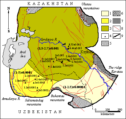
According to the well tests the elastic water yield factor of the complex varies from 0.001 to 0.009 square m/day, decreasing in the South-Western part of the described territory down to 0.0001-0.0003 square m/day.
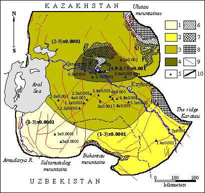 |
Schematic map of elastic water yield of aquiferous complex of Upper-Turon-Senonic depositions of Eastern Priaralye
Value of elastic water yield: 1 – (1-3)x0.0001, 2 – (1-2)x0.001, 3 – (2-5)x0.001, 4 – (4.9-8.75)x0.001; 5 – places of location of elastic water yield as of the results of experimental-filtrational works; 6 – absence of aquiferous complex; 7 – outflows of aquiferous complex onto day surface; 8 – outcrops of Paleozoic rocks onto day surface; 9 – tectonic breaks; 10 – boundary of the region of investigations
The groundwaters are fresh waters (0.3-0.4 g/l) of hydro-carbonate calcium composition in the areas of aquiferous sediments' outcrops or their shallow occurrence at the South-Western slope of the Karatau. At advance to the West the mineralization of the groundwaters increases up to 1.5-3 g/l, and up to 3-5 g/l nearby the Aral Sea. In the Northern Priaralye the mineralization of the groundwaters of the Upper Turonian-Senonian complex reaches 5-10 g/l, and waters' chemical composition become chloride-sulphate.
 |
Schematic map of mineralization of groundwaters of Upper Turon-Senonian aquiferous complex of Eastern Priaralye
Mineralization of groundwaters, g/l: 1 – less than 1, 2 – 1-1.5, 3 – 1.5-3, 4 - 3-5, 5 – 5-10, 6 – 1-10, 7 – more than 10. Outcrops of depositions onto day surface: 8 - that of Paleozoic, 9 - Upper Turon Senonian; 10 - absence of aquiferous complex of Upper-Turon-Senonian depositions; 11 - tectonic breaks; 12 - boundary of the region of investigations
Almost throughout the entire described territory the aquiferous complex of the Upper Turonian-Senonian sediments overlays the clayish sediments of the Lower Turonian. Clay top occurrence depth in the depressions reaches 1400-1600 m, and as a rule in the Priaralye this depth doesn't exceed 500-600 m. The clays' thickness is not big and varies from 20 m in the North-Western part of the region to 100 m in the South-Eastern part.
 |
Schematic chart of bedding depths of roofing of the second from the surface regional confining bed of Eastern Priaralye
1 - isolines of the depths of bedding of roofing of water-resistant depositions, m; 2 - absence of water-resistant depositions; 3 - exposures of water-resistant depositions onto day surface; 4 - exposures of Paleozoic rocks onto day surface; 5 - investigations region boundary.
 |
Schematic chart of thickness of the second from the surface regional confining bed of Eastern Priaralye
Thickness of water-resistant depositions, m: 1 - less than 10, 2 - from 10 to 20, 3 - from 20 to 30, 4 - from 30 to 40, 5 - from 40 to 50, 6 - from 50 to 60, 7 - from 60 to 70, 8 - from 70 to 90, 9 - more than 90. 10 - absence of water-resistant depositions; 11 - exposures of water-resistant depositions onto day surface; 12 - exposures of Paleozoic rocks onto day surface; 13 - investigations region boundary.
Upper Albian-Senomanian aquiferous complex. The aquiferous complex of the Upper Albian-Senomanian sediments is distributed almost everywhere in the Priaralye. The waters are pressured. The complex occurs mainly at the depths of 50-100 m in the area of the Lower-Syr-Darya upheaval, the Ulutau, the Sultanuizdag and the Bukantau foothills. In the Eastern and the Northern Priaralye the occurrence depths increase up to 500-800 m, reaching 1600-1700 m in the downwarps. The complex' deposits are represented by interstratifying marine, lagoonal and terrestrial sediments composed of clays, aleurolites, sands, sandstones. The total thickness of the complex varies from the first tens of meters to 300 m, increasing in the downwarps. The aquiferous rocks' thickness varies from 20-40 m to 180 m.
 |
Schematic map of effective thickness of aquiferous complex of Upper-Albian-Senomanic depositions of Eastern Priaralye
Effective thickness of water-bearing depositions, m: 1 – 0-20, 2 – 21-40, 3 – 41-60, 4 – 61-80, 5 – 81-100, 6 – 101-120, 7 – 121-140, 8 – 141-160, 9 – 161-180, 10 – more than 180; 11 - absence of aquiferous complex; 12 - outcrops of aquiferous complex onto day surface; 13 - outcrops of Paleozoic rocks onto day surface; 14 - tectonic breaks; 15 - boundary of the region of investigations
 |
Schematic map of total thickness of aquiferous complex of Upper-Albian-Senomanic depositions of Eastern Priaralye
1 - isolines of total thickness; 2 - absence of aquiferous complex; 3 - outcrops of aquiferous complex onto day surface; 4 - outcrops of Paleozoic rocks onto day surface; 5 - distribution of Upper-Albian-Senomanic depositions; 6 - tectonic breaks; 7 - boundary of the region of investigations
The groundwaters can be revealed at the depths from 3 to 800 m, the waters are pressured. The minimal pressures can be observed in the Eastern Priaralye. The piezometric levels drawdown occurs at advancing to the Aral Sea – to the regional discharge zone.
 |
Schematic chart of hydroisopiezes of water-bearing complex of Upper Albian-Cenomanian sediments of Eastern Priaralye (as of the State on 1960-65)
1 - hydroisopiezes, m; 2 - absence of water-bearing complex; 3 - exposures onto day surface of water -bearing complex; 4 - exposures of Paleozoic rocks onto day surface; 5 - investigations region boundary.
Throughout the area the water transmissivity varies from 50-100 square m/day to 800-1000 square m/day
 |
Schematic chart of transmissivity of water -bearing complex of Upper- Albian-Cenomanian sediments of Eastern Priaralye
Water transmissivity, square m/day: 1 - less than 50, 2 - from 50 to 100, 3 - from 100 to 300, 4 - from 300 to 500, 5 - from 500 to 800, 6 - from 800 to 1000, 7 - from 1000 to 1200. 8 - absence of water-bearing complex; 9- exposures onto day surface of water -bearing complex; 10 - exposures of Paleozoic rocks onto day surface; 11 - investigations region boundary.
The complex' elastic water yield factor varies from 0.00001 to 0.001 square m/day.
 |
Schematic map of elastic water yield of aquiferous complex of Upper- Albian-Senomanic depositions of Eastern Priaralye
Value of elastic water yield: 1 – (1-2.5)x0.00001, 2 – (1-5)x0.0001, 3 – (1.5-2.7)x0.001; 4– absence of aquiferous complex; 5 – outflows of aquiferous complex onto day surface; 6 – outcrops of Paleozoic rocks onto day surface; 7 – tectonic breaks; 8 – boundary of the region of investigations
The groundwater mineralization varies from 1 g/l in the Eastern part of the territory to 10 g/l in the Northern Priaralye (Fig.). In general it is slightly lower than for the Upper Turonian-Senonian complex.
 |
Schematic map of mineralization of groundwaters of Upper Albian-Senomanic aquiferous complex of Eastern Priaralye
Mineralization of groundwaters, g/l: 1 – less than 1, 2 – 1-1.5, 3 – 1.5-3, 4 – 3-5, 5 – 5-10, 6 – more than 10. Outcrops of depositions onto day surface: 7 - that of Paleozoic, 8 - Upper-Albian Senomanic; 9- absence of aquiferous complex of Upper Albian-Senomanic depositions; 10 -tectonic breaks; 11 - boundary of the region of investigations
The water temper ature here varies from 15°С within the Lower-Syr-Darya apex to 30-35°С in the most plunged areas of the territory. These waters can be utilized for economic and drinking purposes after precooling and as heat-and-power source. The lower aquifugeous formation, which separates the Upper Albian-Cenomanian complex from the Neocomian-Aptian, is poorly explored. This aquifugeous layer is highly conditioned and differs from upper and lower-laying sediments only with excessive shaliness.
 |
Schematic map of roofing elevation depth of the third from surface regional water stratum of Eastern Priaralye
Elevation depth of roofing of aquifugeous depositions, m: 1 - less than 100; 2 – 100-200; 3 – 200-300; 4 – 300-400; 5 – 400-500; 6 – 500-600; 7 – 600-700; 8 – 700-800; 9 – 800-900; 10 – 900-1000; 11 – 1000-1200; 12 – 1200-1500; 13 – 1500-1700; 14 – 1700-2000; 15 – more than 2000; 16 - absence of aquiferous complex; 17 - outcrops of Paleozoic rocks onto day surface
Lower-Middle Albian-Jurassic aquiferous complex. The aquiferous complex of the Lower-Middle Albian-Jurassic sediments is poorly explored. It occurs at the depths from 100-200 in the areas of the rim rocks and the Lower-Syr-Darya upheaval to 1500-2000 m in the South-East of the territory.
 |
Schematic map of roofing elevation depths of aquiferous complex of Lower-Middle-Albian-Jurassic depositions of Eastern Priaralye
Elevation depth of roofing of aquiferous complex, m:1 – less than 100; 2 – 100-200; 3 – 200-300; 4 – 300-400; 5 – 400-500; 6 – 500-600; 7 – 600-700; 8 – 700-800; 9 – 800-900; 10 – 900-1000; 11 – 1000-1200; 12 – 1200-1500; 13 – more than 1500; 14 - absence of aquiferous complex; 15 - outcrops of Paleozoic rocks onto day surface
The total thickness of the aquiferous complex, represented by multi-grained sands and sandstones, varies mainly from 50-100 m in the boundary areas of the described territory to 500 m and more in Mynbulak, the Eastern- and the Southern-Priaralye basins.
 |
Schematic map of effective thickness of aquiferous complex of Low-Middle-Albian-Jurassic depositions of Eastern Priaralye
Effective thickness of water-resistant depositions, m: 1 – 0-50, 2 – 51—100, 3 – 101-200, 4 – 201-300, 5 – 301-400, 6 – more than 400; 7 - absence of aquiferous complex; 8 - outcrops of Paleozoic rocks onto day surface; 9 - tectonic breaks; 10 - boundary of the region of investigations
 |
Schematic map of total thickness of aquiferous complex of Low-Middle-Albian-Jurassic depositions of Eastern Priaralye
1 - isolines of total thickness; 2 - absence of aquiferous complex; 3 - outcrops of Paleozoic rocks onto day surface; 4 - distribution of Low-Middle-Albian-Jurassic depositions; 5 - tectonic breaks; 6 - boundary of the region of investigations
Usually the waters are highly pressured. Water-content of the sediments is not high; wells' self-flows comprise 3-5 l/s. Mineralization varies from 2-3 g/l to 20-100 g/l in the Aral Sea area.
 |
Schematic map of groundwaters mineralization of Lower-Middle Albian-Jurassic aquiferous complex of Eastern Priaralye
Mineralization of groundwaters, g/l: 1 – less than 1, 2 – 1.5-3, 3 – 3-5, 4 – 5-10, 5 – 10-20, 6 – more than 50; aquiferous complexes distribution contours: 7 – that of Neokom-Aptian depositions of Lower Cretaceous, 8 - Jurassic depositions; 9 - absence of Lower Mid dle Albian-Jurassic aquiferous complex; 10 - outcrops of Paleozoic depositions onto day surface, m; 11 - regions of absence of information; 12 - tectonic breaks; 13 - boundary of the region of investigations
On the described territory the aquiferous complex of the Jurassic sediments is developed locally and has been explored extremely insufficient in relation to the hydrogeology. It is characterized by big occurrence depth; the groundwaters are mineralized with temperature up to 40 °С. Water-content of the sediments is low. On the maps both complexes are integrated into one – the Lower-Middle Albian-Jurassic.
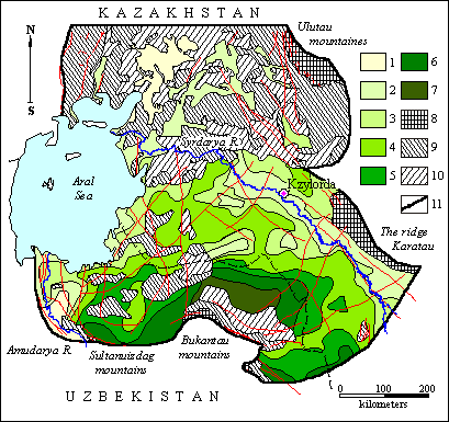
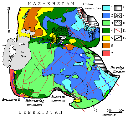
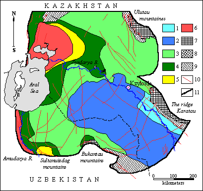
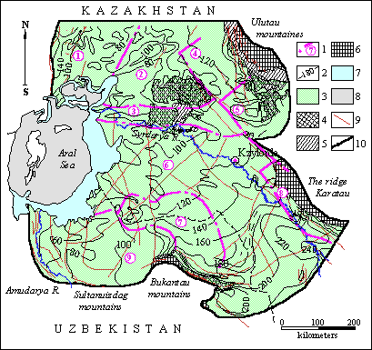
ГThe hydrogeological zoning of the Eastern Priaralye has been performed differentially for the Paleogene, the Neogene-Quaternary and the Upper Turonian-Senonian aquiferous complexes. This zoning was based on the structural-tectonic and hydrodynamic properties. The last ones have been based on the principle of feeding and discharge zones' unity, and the filtration properties differences of the aquiferous rocks have been considered as well. This approach has been borrowed from [Syrdaryinski artesian basin: mathematical modeling of groundwaters resources on the technogenesis conditions, 1992 (in Russian)]. The authors applied it for zoning of the Syr-Darya artesian basin, which occupies the greater part of the described territory. Initially for each of them, according to the hydrodynamic networks of the aquiferous complexes, the water-balance areas have been determined, for which the variation dynamics of discharge flows has been evaluated; then the places of their origination and locations of additional feeding and discharge have been deter-mined. For each of the evaluated block the water balance has been composed based on the field observations of atmospheric pre-cipitations infiltration, evaporation from the groundwaters level, etc. [Veselov V.V., 1995].
Schematic map of zoning of aquifer-ous complexes of the Paleogene and the Neogene-Quaternary sediments of the East-ern Priaralye is illustrated on Figure. To-tally 11 areas have been picked (four - within the South-Turgai artesian basin and seven - within the Syr-Darya artesian ba-sin); during the simulation process we cal-culated the water balance for each of them.
 |
Schematic map of zoning of aquiferous complex of Paleogenic and Neogenic- Quaternary (P-N-Q) depositions of Eastern Priaralye
1-boundaries of water-balance regions and their numbers: [1,2,3,4 - balance parts of Southern Turgai artesian basin: 1-Malye Barsuki (1a - Neogenic-Quaterary complex, 1б - Paleogenic complex), 2 - Priaralski Karakums, 3 - Aryskum, 4 - Betpakdala, 5-11- balance parts of Syrdaryinski artesian basin: 5 - lower current of the river Syrdarya and transition zone from Southern- Turgai artesian basin to Syrdaryinski artesian basin, 6 - Southern-Priaralski basin-lower current of the river Amudarya and Western Karakums, 7 - Northern Kyzylkums, 8 - Eastern Kyzylkums; 9,10,11 - parts of piedmonts of Southern-Western Kara- tau]; 2 - hydroisohypses, m; 3 - distribution of aquiferous complex of Neogenic-Quaternary depositions; 4 - distribution of sporadically flooded Neogenic-Quatenary depositions; 5 - absence of water-bearing complex of Neogenic-Quaternary depo- sitions; 6 - contour of distribution of Upper-Eocenic depositions. 7 - outcrops of Paleozoic depositions onto day surface. Contour of water area of Aral sea as of the state for the year: 8 -1960, 9-1989; 10 - tectonic breaks; 11- boun- dary of the region of investigations
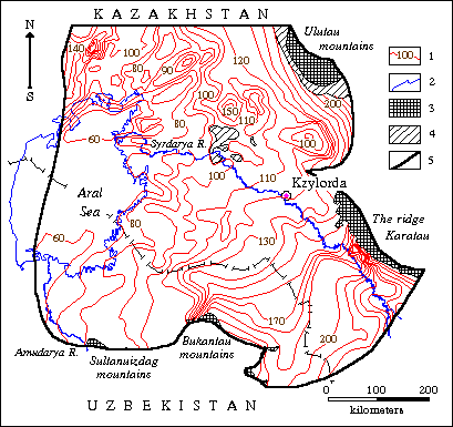
Nine water-balance areas have been picked in the Upper Turonian-Senonian sediments during the zoning of the aquifer-ous complex. Two - within the Northern-Priaralye artesian basin, four - within the Syr-Darya artesian basin. The Mynbulak and the Aryskum artesian basins as well as the Northern-Priaralye and the Syr-Darya artesian basins contact zone are located within the boundaries of the described terri-tory. Zoning results for the Upper Tu-ronian-Senonian aquiferous complex are illustrated on Figure below.
 |
Schematic map of zoning of aquiferous complex of Upper Turon-Senonian depositions of Eastern Priaralye
1 - Boundaries of water balance regions and their numbers:(1,2 - Northern-Priaralski artesian basin; 3 - zone of contact of Northern Priaralski and Syrdaryinsli artesian basins; 4-Mynbukakski artesian basin of the second order; 5 - Aryskumski artesian basin of the second order; 6,7,8,9 - balance parts of Syrdaryinski artesian basin: 6 - Eastern-Priaralski, Eastern-Kyzylkumski and Ergashkudukski artesian basins; 7 - region of Northern Kyzylkums; 8 - Piedmonts of Karatau; 9 - Southern-Priaralski artesian basin); 2 - hydroisopiezes, m; 3 - distribution of aquiferous complex of Upper Turon-Senonian depositions; 4 - outcrops of Upper Turon-Senonian aquiferous complex onto day surface; 5 - absence of aquiferous complex of Upper-Turon-Senoni- an depositions; 6 - outcrops of Paleozoic depositions onto day surface. Contour of water area of Aral sea as of the state for the year: 7 -1960, 8 -1989; 9 - tectonic breaks; 10 - boundary of the region of investigations
Groundwaters of Priaralye have come into utilization intensively from sixties, for the first time for economic-potable water supply of the population of settlements of the region. This has led to the considerable wearing away of their heads. At the same time a large quantity of irrigated areas have been introduced into exploitation at the expense of surface waters which, in dependance from their location have caused not equal influence onto groundwaters formation. Irrigated areas situated in piedmont zone of Karatau ridge, together with surface sink are the source of groundwaters resources formation. Losses of irrigating waters in upper parts of alluvial fan of Southern-Western slopes of Karatau ridge, as of data of field experimental investigations of various water economic organizations, are equal to 5.9 cubic metres/sec. From them 5.7 cubic metres is lost in Neogenic-Quaternary depositions and 0.2 cubic metres - at the places of outcrop onto surface of Cretaceous depositions [Veselov V.V., 1995].
On the territory of irrigated areas situated at the valley of Syrdarya river is noted continuous increase of the levels of groundwaters on multiannual profile. At shallow occurrence of the level of groundwaters( less than 10 m) and further quick elevation of it up to critical depth intensive evaporation begins which lowers the rate of the further increase and then moment of its relative stability takes place. Under relatively deep( more than 10 m)occurrence of the level of groundwaters (Chiili, Arys-Turkestanic areas) irrigation has led to the fulfilling of free volume and to the increase of the capacity of horizon of groundwaters up to 3 - 5 m not only in the region of the irrigated areas themselves but also at the distance of 30-40 km from them. Because of this groundwaters resources increase on the large territory has taken place. At the same time at the regions of irrigated areas at the first from surface water-bearing horizon the appearence of nitrates, nitrites, ammonium, ammonia phenols is noted, increased values of oxidative ability is observed, Groundwaters pollution is registered also in some water intakes. In Kzylorda province to them belong: Terenozekski, Kyzylkumski, Kyzylordinski, Baikhodzhinski, Tolagaiski, Shiiliski, Zhidelinski deposits. As polluting components are: iron (2.0-12.0 maximum permissible concentrations- MPC), manganese (2.0 MPC), chlorides (2.0-6.0 MPC), sulphates(1.0-2.0 MPC), increased mineralization(1.3-3.0 MPC). Influence of technogenic processes onto quality of head waters of Upper Cretaceous horizons has reflected in the lesser degree. Groundwaters consumption is the fundamental factor of technogenic influence onto hydrogeological conditions of Priaralye. Their role as basic source of economic-potable water consumption of cities, regional centres, agricultural settlements has especially increased during last years in connection with the fact that surface waters of Syrdarya river practically on the whole length of the river have become unsuitable for the provision of the population with potable water. For the estimation of water consumption of groundwaters from working water supplies data of basin inspections which have made the corresponding estimation have been taken into consideration. The largest practical value have waters of Neogenic- Quarternary Upper-Turon-Senonian water-bearing complexes.
Neogenic-Quarternary water-bearing complex is used only on the parts along the river bed and in the regions of piedmonts of Karatau ridge where groundwaters are fresh or weakly subsaline. As basic users of the groundwaters of this complex are the cities of Kzyl-Orda, Turkestan, Arys. Besides this groundwaters are used for water supply of more than 20 agricultural settlements. There are 14 small water intakes with the productivity from 0.2 to 35 l/sec in the boundaries of Kzyl-Orda province. As the most largest of them is the water supply of the city of Kzyl-Orda, working from 1977.
Water-bearing complex of Upper-Turon-Senonian depositions has important value as the source of economic potable water cosumption of the population of this region. Basic users of water are attracted to the valley of Syrdarya river and piedmonts of Karatau. Groundwaters are exploited as a rule with the help of small water intakes consisting from 2-3 bore holes or from separate bore holes with the productivity of the order of 10 l/sec. There are about hundred of such water supplies in this region. As the most powerful of them are: Baikhozhinski (water consumption about 50 l/sec), water consumption of Kzyl-Orda water supply line and sewer system(160-180 l/sec). On the Southern side of Lower-Syrdarya roof, Left bank water supply is working with the productivity of 0.9 cubic metres/sec. Upper-Turon- Senonian depositions groundwaters exploitation has begun in the region from 1964. To the end of 1989 total water consumptionn has reached 2.8 cubic metres/sec. At the boundaries of the distribution of this complex are working some hundreds of ownerless self- flowing bore holes. In accordance with the data of inspection (1981-1983) there were about 900 self-flowing bore holes with total output of 1.4 cubic metres in Kzyl-Orda province and about 260 bore holes with output of 1.0 cubic metres in Shymkent province. Their values are somewhat lower in comparison with expenditure (about 3.4 cubic metres/sec) which has been fixed in this region as for data of inspection in 1971.
НOn the territory of the Republic of Uzbekistan entering into the region investigaterd change of self-flowing of bore holes looks like this: 1964 - regulation of exploitational bore holes is made and they have received valve regime, in accordance with the necessity existed for water. In the result of these measures water consumption has lowered and has became as of the state for the year 1989 about 1.0 cubic metres/sec with the practically completely termination of water consumption on the parts of oasis irrigation. Data given above are taken from the materials of Southern- Priaralye hydrogeological group [Fetisov V.G., 1988].
Water consumption from Upper-Albian- Cenomanian water-bearing complex is insignificant in comparison with other complexes and is not more than 50 l/sec.
. Intensification of technogenic factors has led to lowering of the groundwaters levels and to changing of their balances by all the water-bearing complexes. Quantitatively these changes were estimated at the process of the execution of mathematical sumulation of the hydrogeological conditions of Priaralye. (Section "Results of simulation").
 |
|
 |
|||||||||
Previous |
Next |