1. Investigations region location | |
2. Orography | |
3.Climate | |
4. Hydrography | |
5. Geological structure and tectonics | |
Arid bioclimatic zones with quantity of atmospheric precipitations of 100-200 mm/year and semi-arid, 200-400 mm/year, isolated by UNESCO (1977) on the standardized map of the globe with scale 1:25 000 000, include also the territories of the South of Kazakhstan, where is situated, ex-unique Aral sea. These territories are included into the structure of African-Asiatic arid region [Strakhov N.M., 1962]. Overall geographical attraction of the arid zones on Earth's ellipsoid (Northern-American, South-American and African-Asiatic), to the latitudes less than 35 degrees is caused by a set of factors: instability of ellipsoid on these near-equatorial latitudes, connected with unequal rotation of the Earth, tidal forces, precession and nutation, mathematically substantiated by A.Poincare; by geotectonic peculiarities - all the arid zones are surrounded by the highest mountain peaks [A.A.Tillo, 1889]; by the peculiarities of atmospheric circulation, and also by the set of climatological indexes, expressing in sharp deficiency of humidity and by very high - more than 3, index of aridity of Budyko-Grigoryev, which reflects the ratio of radiational balance and heat expenditures for evaporation of the atmospheric precipitations [Budyko M.I., 1977; Kazakhstan //Natural conditions and natural resources of USSR, 1969 (in Russian); Ostrovski V.N., 1991]. Originality and characteristic peculiarities of the natural conditions of groundwaters formation of Eastern part of Priaralye are caused also by its location in the centre of the largest internal-drainage region of Eurasia - Turan depression, the basic part of which is occupied by the flatlands of various genesis with general inclination to Aral sea, encircled by mountain structures of the foundation of Turan platform [Atlas of KazSSR, 1982 (in Russian); Kazakhstan //Natural conditions and natural resources of USSR, 1969(in Russian)]. The region of investigations with total area of the order of 500 thousand square km, is limited on West by Kulandinski-Amudaryinski swell (swell of Arkhangelski) and on North-East - by Karatau fracture - systems of lineaments of ancient deep laying of foundation; on South and East - by mountain structures of Sultan-Uizdag, Bukantau, Karatau and Ulutau; on North-by Turgai river latitude.
|
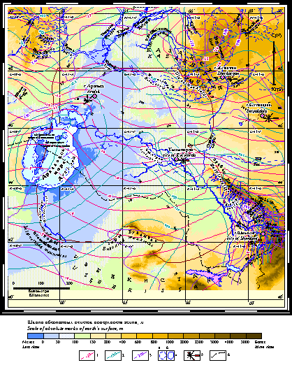
Map of climatic indexes of Eastern Priaralye
Izolines of mean monthly temperature of air, C: 1 - January; 2 - July; 3 - isolines of atmospheric precipitations, mm/year; 4 - water area of Aral sea as of the state for: a) 1961, b) 1989; 5 - wind rose; 6 - State boundary of the Republic of Kazakhstan
Diversity of the natural conditions of this vast territory causes the variegated picture of formation and distribution of groundwaters allowing substantially to isolate a series of hydrological-hydrogeological regions. Differing among themselves by orographic, hydrographic, climatic, landscape and geotectonic conditions of groundwaters (subsoil and head) formation, these regions are united by the history of the geological development and modern dynamic of groundwaters discharge at Mezo-Cenozoic protective covering of Turan platform, where groundwaters are exclusively porous and stratum-porous, while at rocks of platform of encircling mountain structures they are of porous-fissure and fissure-karst types.
Vast stratum valleys, situated above the ocean level only by tens of meters occupy the greater part of Eastern Priaralye. These valleys are both flat or hilly from eolic formation of sandy massives, or are characterized by the combination of flat territories and dividing them deep depressions.
Aral sea basin is situated in the region of complex interlink of the structures of platform of Uralski and Tien-Shanski types sub-meridianal and sub-longitudal directions, occupying central part on the West of the territory considered.
To the North from Aral sea, at the North-Western corner of the territory of investigations is situated so called Northern Priaralye, formed by lowland, rugged onto mesa uplands, occupied with sor-deflational hollows with many solonchaks and sandy massives: Bolshye and Malye Barsuki, and Priaralski Karakums. Geomorphostructures of Northern Priaralye are the bright example of the reversed forms of relief, when to the axes of positive geostructures correspond negative forms of relief, and vice versa - to negative geostructures correspond positive forms of relief [Yanshin A.L., 1953].
North-Eastern corner of this territory is limited by Ulutau low-mountains and area of low, rounded isolated hills with height up to 1133 m, being the frame of decomposed mountain system, characterized by not deep but fractional ruggedness. To all the sides from Ulutau run down drying up during summer river systems including Kalmakkyrgan, which flows into large bitter-salted lake Shelkar-Tengiz, which is the lowest point ((80 absolute meters) of the Northern boundary of the territory.
Between Northern Priaralye and Ulutau is situated flat unrugged lowland, smoothly transforming to the South into not high dome-shaped weakly rugged Nizhne-Syrdaryinski dome upheaval with maximal height up to 266 m.
The Southern half of the territory is occupied by the large desert of Kyzylkums with heights from 53,4 m (former level of Aral sea for the year 1960) up to 332 m near the foot of the mountains Bukantau, limiting the desert on the extreme South of the territory. The relief of the desert is ridge-cellular or ridge-hilly and even hollow-cellular. Framework of the relief forms ancient crumbling plateau divided by grooved hollows with depth from 20 to 80-100 m. Ring dunes - deflational small hollows of the diameter 20-40 m predominate on central and Northern parts of the desert. Sands are stabilized by bushwood-ephemeral vegetation, and degree of stabilization increases from West to East [Kazakhstan //Natural conditions and natural resources of USSR, 1969 (in Russian)].
On the extreme West of the Northern part is situated vast alluvial-delta flatland of Upper-Quaternary-modern age, formed, near the issue, by the river Amudarya and numerous its branches in the form of natural active and dry river beds and also by rich irrigation system, lacustrine and solonchak depressions. This flatland is very sharply isolated by its geomorphological and landscape appearance on the back-ground of the encircling desert spaces of Ustyurt, Kyzylkums and Zaungusski Karakums. Lowlands, situated downstream of Amudarya represent themselves a monotonous flatland, consisting exclusively from delta detritus of Amudarya, gently sloping to the North to Aral sea, and to the West - to Sarykamysh depression. Not numerous elevations with relative height of 60-80 m, composed by the outcrops of Cretaceous and Neogen-Paleogenic depositions are sharply distinguished on the background of this flatland. Alluvial-delta lowland of Akchadarya, separated from the modern delta of Amudarya by well-delineated bench up to 1.5 m with massifs of eolic sands and deflational hollows is developed on the right shore of Amudarya near the foot of Eastern slopes of Sultan-Uizdag. [Volvovski I.S., 1966].
Vast Syrdarya alluvial-delta flatland cut by benched valley of the river Syrdarya, running down from Western Tien-Shan into Aral sea, and of its former rivers: Zhanadarya, Kuvandarya, etc., forming in whole the ancient and modern deltas, occupies the central sub-latitudal part of this territory. In Eastern South-Eastern direction its surface is gradually elevating and transforms into alluvial-proluvial piedmont flatland of the Karatau ridge with heights of 500-750 m. Ridge, hilly-ridge, hilly-cellular sometimes barhan sands, composing the Northern part of the vast sandy desert of Kyzylkums are widely distributed along the all the left shore of the river Syrdarya, and sandy massif of Ayakkums is situated on the North-Eastern corner of the territory, near the foots of Ulutau [Kazakhstan //Natural conditions and natural resources of USSR, 1969 (in Russian)].
Catastrophic lowering of Aral sea level has led to the formation along its shores and around islands, of sandy-clayish flatland, sometimes divided from "main" shore by bench [Rubanov I.V., 1987]. Its flat slightly inclined surface with heights 32-53,4 m (as of the state for the year 2003) is complicated by the forming sor-deflational depressions and by the positive forms of eolic microrelief.
Thus, as the basic morphogenetic types of modern relief, controlling together with lithofacial composition of the rocks of the bed and cover, trend and intensity of ground water-salt discharge of Turan platform, are [Atlas of KazSSR, 1982 (in Russian)]; [Kazakhstan //Natural conditions and natural resources of USSR, 1969 (in Russian)]:erosional and denudational low-mountains and surfaces of planation of encircling mountain structures (Ulutau, Karatau, Bukantau, Sultan-Uizdag) (Fig.); stratified denudational uplands, plateau and lowlands sometimes shifted, with superposed solonchak internal-drainage depressions, alluvial-deltaid flatland of the river Syrdarya and its former rivers with piedmont inclined lowland and slopewash tails (piedmonts of Karatau); lacustrine lowlands situated in interfluvial area of Syrdarya and Chu-Sarysu; marine, lakustrine shifted lowlands and eolic lowlands of drift; sandy massives of Karakums, Priaralski Karakums, Aryskums, Bolshie and Malye Barsuki, etc.
Low-mountains and ancient surfaces of planation - from 100 to 400 m and low-hilly, residual mountaineous uplands - from 60 to 100 m are characterized by the greatest depths of relief ruggedness. Accumulated lowlands are characterized by the least depths: 1-2 m - recent and 20-50 m - ancient piedmont; 1-5 m - recent and up to 100 m - ancien alluvial; 1-3 m - lacustrine and marine lowlands; 3-15 m shifted and eolic lowlands of drift. Erosive and denudational lowlands as of their depth of ruggedness occupy intermediate place: 10-60 m - abrasive plaleau and lowlands of Neogenic-Paleogenic and Cretaceous depositions; 15-20 m erosive stratum-stage Paleogenic uphilled lowlands of lower part of the river Turgai; 3-60 m - stratum denudational uphills, platean and lowlands of Neogenic-Paleogenic and Cretaceous depositions of Northern Priaralye; 30-60 m - shifted denudational uphills, platean and lowlands of Neogen-Quaternary depositions.
Relief ruggedness depth defines not only the regional but also the local character of groundwaters (ground and head) levels behavior, intensity of their water-exchange, and hence their hydrochemical quality, resources, ecological state and possibilities of economical utilization.
Location of the territory of investigations at the centre of Turan depression and Eurasian continent at the zone of temperate latitudes and far from oceanic water areas sharply aggravate seasonal differences of the most important climatic parametres and, first of all, of radiational regime. Therefore, climate of Priaralye bears characteristic features of marked continental with considerable oscillations of annual and daily temperatures of air: annual amplitude of median monthly temperature reaches 30-40 °С
Abundance of light and warm - the most characteristic peculiarity of the region, because the duration of sun radiation reaches in South-Eastern part of the territory of the largest values - 3000 and more hours per year, and on the residual part of the territory is not lower than 2800 [Atlas of KazSSR, 1982 (in Russian)]. Annual radiational balance here is positive and is equal almost to 1800 MJ/square m. This is connected not only with southern positions of the territory, but also with considerable nebulosity during warm period of year. Summer, thank to enormous value of sun energy, highly dehydrated surface and large relative dryness of air masses takes place intensive convection, excluding occurrence of nebulosity at the expense of water vapours condensation. Therefore, the number of bright days reaches here 260 days per year with summary radiation up to 130-150 kcal/square cm, with increase to the South. Absorbed radiation is also increasing to the South; and its value thanks to albedo is less than natural one. The largest values of albedo (70-80%) are characteristic for Winter season with stable snow cover, lowering in Summer to 20-30% [Kazakhstan //Natural conditions and natural resources of USSR, 1969 (in Russian)]. Large period of sun radiation guarantees considerable helio-energetic resources of territory, which together with enormous geothermal potential of Arys depression groundwaters attains substantial practical thermo-energetic value.
Such high radiation creates the objective conditions for high evaporation from soil surface, 100-200 mm/year, and formation of the most low in Kazakhstan index of humidity of grounds (0,1-0,15), which leads to deepening of groundwaters levels, to the increase of their mineralization and to the salinization of grounds. And potential possibility of moisture evaporation (evaporability) reaches 900-1200 mm/year, at the boundaries of Aral sea 1000-1100 mm/year and evapotranspiration is even more - 2000 mm/year and more during vegetation period, which on one order exceeds the quantity of atmospheric precipitations mean annual value of which changes from 80-90 mm on South-West, in Priaralski Kyzylkums, up to 160-370 mm on the North and up to 400-650 mm in piedmont and mountain zone on the South-East territory [Atlas of KazSSR, 1982 (in Russian)]. In this case, mean annual and monthly temperature of air in whole increases from North to South and from the mountains to lowlands, and the sum of atmospheric precipitations changes in reverse direction.
Small quantity of atmospheric precipitations is responsible for low relative humidity of air especially in Summer time (from 15-35% on South and West and up to 40-45% on North and in region of Aral sea). In Winter its value increases considerably and reaches, respectively 60-85%. In reverse direction as of the seasons of the year absolute value of humidity changes, correspondingly, in Winter and Summer from 1,7-2 and 11-13 mbars on North up to 3-5 and 12-14 mbars on South and West with values of humidity deficiency from 0,2-0,5 and 20-21 mbars on North to 0,7-1,5 and 22-29 mbars on South and West [Atlas of KazSSR, 1982 (in Russian)]. Together with this during Winter period in Priaralye are observed glaze phenomena at the period of replace of frost weather by thaws with fall out of liquid supercooled precipitations. Thus in Kazalinsk, the quantity of such days sometimes reaches 30 under mean duration about six. Such phenomenon is observed also in the region of Ulutau [Kazakhstan //Natural conditions and natural resources of USSR, 1969 (in Russian)].
In formation of the climate of Southern and Central part of Turan depression the enormous value have atmospheric processes, characteristic for Middle Asia in whole. As it is known all this territory is under the influence of Western transfer of air masses with inherent to it processes of cyclo- and anticyclogenesis. With the first one are connected warm and moist Western winds and cold Northern air masses, inducing the lowering of air temperature and falling of precipitations. Mean annual values of air speed in whole lower from North-West to South-East from 5 to 3 m/sec [Kazakhstan //Natural conditions and natural resources of USSR, 1969 (in Russian)].
Great value in formation of surface and ground discharge have capacity, duration of conservation and regime of changing of snow cover as of seasons and in various forms of relief. Maximal height of snow cover as of mean multiannual data at the Aral basin changes from some centimeters on South, West-West and West up to 15-20 cm on North and South-East and in piedmont and mountain region up to 30 cm, with water resources in snow, not exceeding 40 mm on lowlands and increasing in piedmont and mountain regions of Karatau and Ulutau up to 60 mm [Atlas of KazSSR, 1982 (in Russian)].
Atmospheric precipitations, especially snowy, have mineralization up to 20-50 mg/l on North and in piedmont regions, up to 100-140 mg/l on South and West, and in Summer especially after dust storms, the value of it reaches on the lowlands of the value 300-500 mg/l. As of the composition they are hydrocarbonate (in Winter) and hydrocarbonate-sulphate and on West even sulphate (in Summer) calcium-sodium [Ground water-salt discharge at the Aral sea basin. Conditions and prognosis, 1983. (in Russian)]
The territory described is situated at the boundaries of Aral sea basin - the largest internal-drainage reservoir, fed earlier basically at the expense of inflow of surface waters of the rivers Syrdarya and Amudarya, water content of which completely defined the level and saline regime of the sea. Besides river water reservoirs of Syrdarya and Amudarya, Aral sea basin includes also two inner internal-drainage regions: on North - large Northaralski with center at the depression of the lake Shalkar-Tengiz, and on the South-Kyzylkumski, occupied by sand desert of the same name.
Syrdarya river began in the Tien-Shan mountain out of the boundaries of Kazakhstan; its length is 2137 km, basin area 462 thousand square km. Discharge of Syrdarya is regulated by the series of hydro-energetic water storage basins: Kzyl-Ordinski, Chardaryinski, Kairakkumski, Toktogulski. Amudarya river begins in high-mountain system of Pamir, also out of the boundaries of Kazakhstan, on the border with Afganistan (river Pyandzh); its length is 2275 km, basin area 492 thousand square km. Discharge of Amudarya like the discharge of Syrdarya is regulated by the series of hydroenergetic water storage reservoirs. Basic mass of river discharge of the basins of Syrdarya and Amudarya (up to 99%) goes onto the territory of investigations from adjacent territories.
Together with this on the background of the immense deficiency of available surface water resources of the territory investigated at the boundaries of Kazakhstan and neighbouring Uzbekistan in the result of run-off of collector-drainage waters from irrigated massives and flood waters are created numerous anthropogenic constantly filled water reservoirs the most large of which is the lakes Aidarkul and Sarykamysh (on South-Eastern and South-Western boundaries of the territory investigated, correspondingly).
Aral sea by the size of area of water surface - 66 thousand square km (on sea level 53,41 m, 1960) occupied the fourth place in the world after Caspian sea, Upper lake (USA) and lake Victoria (Eastern Africa). Both large islands - Vozrozhdenie, Barsakelmes, Lazarev, and also numerous small ones are at the basin of the sea. The lowerest mark of bottom of the basin situated near Western coast of the sea (out of the limits of the territory of investigations) is by 69 m lower of the mean multiannual level of Aral sea stand at 1960, which by 15 m lower the Baltic sea level. Before 1960, Aral sea represented considerably stable water reservoir with century oscillations of water level (3 m) and seasonal ones ( 25 cm) [Hydrometeorological problems of Priaralye, 1990 (in Russian)].
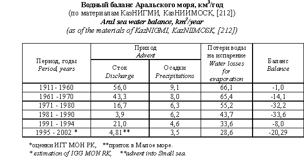
The priority value in water-salt balance of the sea before the year 1960 has belonged to the drainage of the rivers Amudarya and Syrdarya, the total drainage of which during the period of 1911-1960 at the zone of formation - mountain regions of Pamir-Alai and Western Tien-Shan has been of the order 117 cubic km/year (Amudarya - 80, Syrdarya - 37). Inflow into Aral sea has been 56 cubic km/year, including that of Amudarya - 42, and of Syrdarya - 14, with mean mineralization 0,47 and 0,55 g/l, respectively, guaranteeing, together with atmospheric precipitation and evaporating process from the water area, the salinity of Aral water equal to 9,9 pro mille [Ground water-salt discharge at the Aral sea basin. Conditions and prognosis, 1983. (in Russian)].
Beginning from 1960, in connection with the intensive irrigational-hydroenergetic development of water-soil resources of Aral sea basin, total water consumption at the basins of Amudarya and Syrdarya has began to increase rapidly at the expense of the regulation of returnless removal of ground drainage: 7,7 cubic km/year during 1961-1965; 17 cubic km/year during 1966-1970; 30 cubic km/year during 1971-1975 and up to 50 cubic km/year and more at the end of eighties. Thus, beginning from 1960, negative water balance of the sea becomes the norm and during the period from 1970 to 1990 annual deficiency of balance has exceeded 30 cubic km. Formation of such a big deficiency of sea balance in considerable degree has been caused also by the climatological factors - during seventies water content of the rivers Amudarya and Syrdarya has been by 20-25% lower than the norm and total renewable water resources of Aral has become by 20-25 cubic km/year lesser, than before [Severski I.V., 1999] (Table).
 |
As for geological-tectonic relation the whole of Aral sea basin occupies central and South-East part of Turan continental platform and is situated in the field of joining of two types of structures - sub-meridional Uralic and sub-latitudinal Tien Shanic. Paleozoic fundament outgoing onto surface of the Earth on the boundaries of the basin in the regions of mountain constructions is deposited on the depth up to 1.5 km under water landing area of the sea. Water-bearing complexes of the rocks of platform of protective covering in various parts of the basin are deposited with sharp variance on various folded for-mations and on various depths. They have different degree of shielding and conditions of water exchange In the boundaries of Aral sea basin are isolated three structural-tectonic regions: Northern-Priaralski, including Southern-Western part of Turgai depression, Northern -Ustyurtski and Eastern -Aralski. Northern- Priaralski structural block is complicated with Chelkarski depression and Northern-Priaralski system of structures. Total capacity of basic water-bearing compexes of Cretaceous sand-clay and carbonate depositions - from 50-150 m on the North, up to 8-1200 m and more on South-West. Northern Ustyurski structural block on the territory discussed occupies only the outer Northern-Eastern part. Here the capacity of basic water-bearing complexes of Cretaceous depositions is 2.0-26 km, and that of superposed Paleogenic-Neogenic - 0.6 - 1.2 km. Eastern - Aralic system of depressions occupies Eastern and Southern-Eastern parts of basin and is elongated to 500-550 km, from Lower-Amudarya-Sultanoizdag zone of elevations on the South , and up to Aral- Lower- Syrdarya structures on the North. Its width is 200-350 km. In Eastern- Aralic depression the maximal capacity of Jurassic and Cretaceous depositions reaches to 200 m, that of Paleogenic - 350 m.
 |
||
Next |
| [Home] | [Contents] | [Links] | [Autors] |