 |
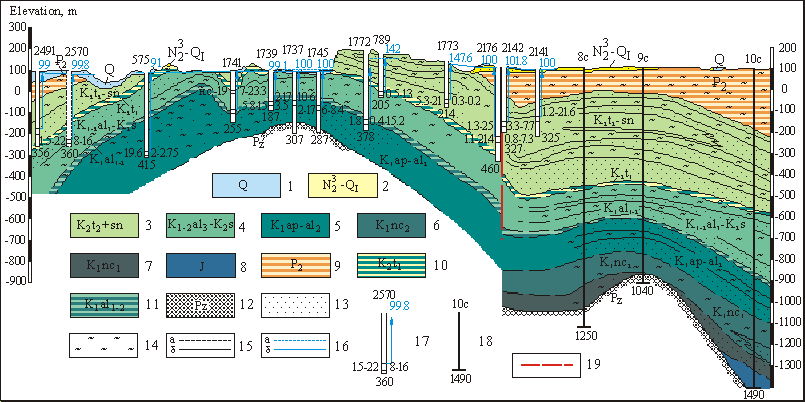
Schematic hydrogeological profile by the line III-III
Aquifers and aquiferous complexes of depositions:1 - Quaternary; 2 - Upper-Pliocenic - Lower-Quaternary depositions; 3 - Upper-Turon-Senonic; 4 - Upper-Albian-Senomanic; 5 - Aptian-Middle-Albian; 6 - Upper-Neocomian; 7 - Lower-Neocomian; 8 – Jurassic. Water-resistant depositions: 9 - Middle-Eocenic; 10 - Lower-Turon; 11 - Lower-Middle- Albian; 12 - surface of Paleozoic sole. Lithological composition of rocks: 13 - for the most part - sands; 14 - clays; 15 - boundaries of aquifers and aquiferous complexes: a - found out, b – supposed; 16 - piezometric level of aquifers: a - Upper-Turon-Senonian, b - Upper-Albian-Senomanic; 17 - hydrogeological well. Numerals: on top - number, from left - water mineralization, g/l, water temperature-centigrades; from right - debit, l/sec, depression, m; at bottom - depth of well, m. Arrow corresponds with groundwaters head, number near arrow - absolute mark of piezometric level of water, m; 18 - geological well. Numerals: on top - number, at bottom - depth, m. 19 - tectonic breaks