
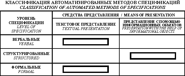
1. Basic conceptions of Eastern Priaralye ground waters resources simulation | |
2. Short characteristics of the complex of instrumental means | |
3. Geoinformational-mathematical model creation methods |
Groundwaters considerably differ from other mineral resources. Resources of groundwaters, their quality and therefore the suitability for the utilization can be considerably changed with time. Therefore it is important not only to estimate their current state but also to forecast future one. Groundwaters state change is conditioned by their movement in hydrolithosphere. But the direct observation of groundwaters movement is extremely difficult.They occur under the earth's surface and are not seen to the observer. It has been found out experimentally that the movement of groundwaters in hydrolithosphere is taking place in the result of interaction of dynamic fields (pressure, temperature, concentration of components diluted in water etc.) and static (geological) fields- water permeability, porosity, water transmissivity, etc. From mathematical point of view dynamic fields are the fields of functions and geological ones - fields of arguments, i.e., those factors which influence these functions. Connection of parametres can be described by the system of differential equations. While solving this system of equations it is possible to calculate the values of dynamic fields onto any moments of time at any point, i.e., to solve the problems of forecasting. It is necessary for this to know the values of static parametres and initial values of dynamic ones. But parametres characterizing groundwaters properties and properties of rocks into which they are enclosed can be measured only in separate cases. With this aim for example bore holes are made in which the necessary measurements are made. In order to find out the laws of the change of static and dynamic parametres in space for the whole territory investigated, and to describe the interrelations among parametres, hydrogeological stratification is executed. As the result of this are special graphic instruments - hydrogeological maps accompanied by hydrogeological profiles and explanatory memoranda including textual descriptions, calculations, tables, graphs of parametres etc.
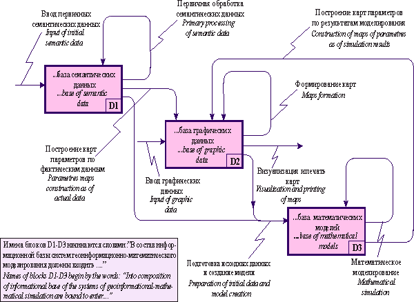
Up to the present moment for Aral region huge true material is collected for thousands of bore holes, numerous scientific works in study of hydrogeological conditions of the region are made, hundreds of hydrogeological maps and profiles of various scale are executed. Analysis of such large volumes of data and forecasting is possible only on the base of utilization of modern informational technologies. Therefore for the simulation of hydrogeological conditions of Eastern Priaralye the Institute of Hydrogeology and Hydrophysics of the Ministry of education and science of the Republic of Kazakhstan has developed and adapted complex of special instrumental means, the basic part of which are geoinformational system, system of simulation of hydrogeological processes. Architecture of complex is shown on the Figure:
|
Architecture of automated informational system of Eastern Priaralye
 |
Taking into consideration large complexity of the subject field discussed and its poor formalization, informational simulation seems expedient to execute in two stages. On the first stage, word description of the field of application is made. On the second stage demands to the system are made more strict. SA-language, developed by D.Ross is used for the reflection of them. Non-processual approach with use of the objects as the initial constructions [Spivak L.F., 1982] is applied during further detailed elaboration of the informational model of data, which are bound to be stored and processed in the system.
The basic principle of SA is used recursively and leads to the decending hierarchical decomposition [Ross D., 1984].
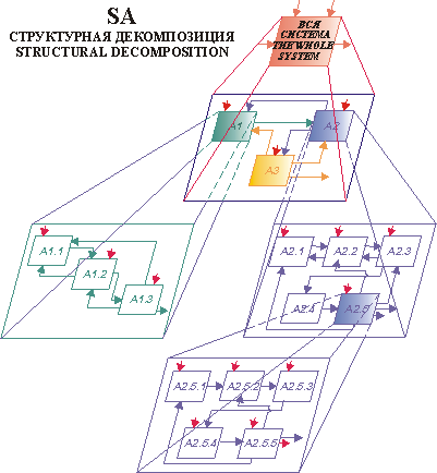 |
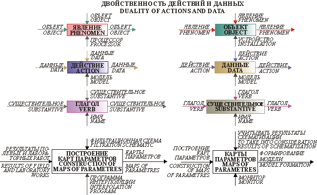
Complete SA-model is bound to describe both phenomena, and also the objects of the field simulated. The phenomena appear as decomposition of actions, and objects – as decomposition of data, mapped by the corresponding diagrams. In such a manner, there is complete duality of phenomena (actions) and objects (data) in SA. The action entering on INPUT of a block of data can be imagined as a certain operation, creating this object, and action, marking OUTPUT – as using the object of data.
 |
Thanks to the fact that SA-language incorporates all the other languages, it becomes possible to use these or those their means for attainment of the concrete aims, connected with: reflection of the pecularities of the subject field; demands, put to the automated informational systems, explanation of the possibilities of instrumental means; description of the procedures and technologies of automated processing of the data, etc. It is possible, on the basis of the demands, fixed using SA, to organise the effective rational projecting of the concrete system, its furthe realization, accommanying, personnel education. Now means are existing, which allow, on the basis of similar specifications, to generate automatically the programs or their fragments (for example, CASE-technologies). Thus, development of consistent and full specifications is the key task. We have used SA-language and its methodology during development of geoinformational-mathematical model of Eastern Priaralye.
MađInfo 5, FOXPRO 3.0 and GMS 3.1 programs are included in the complex of tools for realization of main principles of the geoinformational-mathematical simulation. They execute the functions of creation and maintaining of the graphic and semantic databases, mathematical models of the hydrogeological objects; also they allow solving the conceptual hydrogeological problems on the models. Additionally there is a set of service tools, which provide the data exchange between main components of the system, and the programs, which execute the functions of the reference-information servicing of internal and external users of the system. Below you can find their description.
Geoinformational simulation system MAPINFO. MađInfo software has been used for creation of the Eastern Priaralye geoinformational system. This system provides the direct access to the information, stored in the formats of dBase, Excel, Lotus, ACCESS. Network operations are provided. The complex provides wide capabilities for finalizing of the output documents: large number of fonts, scale control, work in WISIWYG mode. This system supports the MađBasic, MađCode programming languages and building of the users' «menu». This program can handle more than 150 mapping projections. The tools are available for building of users' projections; raster image integration to the vector image and placing of vector image above the raster image. The system supports the input from digitizer, scanner, GPS systems, from the raster substrates and the address geocoding. The tools provide the functionality of images processing, spatial statistics, spatial measurements, thematic mapping, and graphical analysis.
MađInfo is oriented toward the handling of graphical geoimages in vector format. The system supports the layer-by-layer representation of the graphical data. MađInfo handles the point, linear, areal and combined graphical objects; description information can be linked with each of these objects. This information can be easily reviewed during the work with GIS; it also is used to solve the problems of the hydro-geological condition schematization and the primary data preparation for mathematical model.
Database management system FOXPRO. ÄFOXPRO 3.0 Database management system (full name Visual FoxPro 3.0) is applied to create the semantic databases of the Eastern Priaralye data and for handling them [M.D.Antonovich, 1996]. The system allows handling of spreadsheets, containing millions of records, fast enough on the personal computer. There is the capability to design the screens and reports with the help of special designers or wizards (Screen Designer and Report Designer), using the WYSIWYG technology - What You See Is What You Get. The other important features of FOXPRO 3.0 are:
Next versions of FOXPRO differ mainly in capability to create and apply COM servers, and to publish the applications in INTERNET. There are following features for the Visual FoxPro data access through WEB:
Description of one of the latest versions of Visual FoxPro can be found in [Baziyan, 2001].
Mathematical simulation system GMS 3.1. At the present time we carry out the conversion of the mathematical model of the Eastern Priaralye hydrogeological conditions into the formats of GMS 3.1 simulation system – one of most perfect system of the hydrogeological processes simulation and having the wide functional capabilities. Below you can find its brief description, which had been composed basing on the operational manual of the system.
System GMS 3.1 is designed for simulation in the zones of complete and incomplete saturation of the groundwaters' motion and transfer of the water solute substances, building of the flow lines, etc. Also this complex includes the tools for model calibration and simulation results visualization, tools for building of triangulation irregular network, building of three-dimensional models of stratigraphy and some other components. Full version of the system contains the graphic user interface and a package of programs – MODFLOW, MT3DMS, RT3D, SEAM3D, SEEP2D, FEMWATER, UTCHEM, NUFT, PEST, MODPATH.
Graphic interface is divided into 10 modules – TIN, Borehole, Solid, 2D Mesh, 2D Grid, 2D Scatter Point, 3D Mesh, 3D Grid, 3D Scatter Point, Map.
GMS 3.1 system is assimilated and adapted into the complex of geoinformational-mathematical simulation. Below you can find the brief characteristics of its main components.
Program MODFLOW simulates the three-dimensional filtration of the groundwaters flow in heterogeneous and anisotropic environment. The finite-difference method is applied. Area, where the flow is simulated, is approximated by orthogonal uniform or non-uniform network, which includes rows, columns and layers. Layers can be pressured, non-pressured and pressured-non-pressured. The model can consider the influence of water wells, areas of feeding and discharge, drain lines and various surface water objects on the groundwaters.
Program MT3DMS simulates the three-dimensional transfer of the solute contaminating components by the groundwaters.
Program RT3D simulates the hard and solute contaminating components transfer by the groundwaters under consideration of chemical and microbiological reactions.
Program SEAM3D simulates the solute components transfer by the groundwaters under consideration of aerobic and further anaerobic decomposition.
Program SEEP2D is designed for creation of flat horizontal and profiled models of the groundwaters motion in isotropic and anisotropic, homogeneous and heterogeneous environment. The pressured and non-pressured profiled flow in the zone of complete and incomplete saturation, pressured planned flows in the zone of complete and incomplete saturation are simulated. Horizontal drainage and well operations are simulated.
Program FEMWATER is designed for simulation of three-dimensional flow of the groundwaters in the zones of complete and incomplete saturation under consideration of variations in density of filtered fluid. FEMWATER applies the finite-element method. GMS 3.1 system includes the graphic interface to operate the FEMWATER program. Then the conceptual model of the hydrogeological object, created with the help of special tool, is reflected to the three-dimensional network (Fig.98) in the formats used by FEMWATER.
 |
View of conceptual model of the hydrogeological object, reflected to the three-dimensional triangular network
Program UTCHEM is designed for simulation of the subsurface three-dimensional flow of multi-phase fluid, as well as transportation of solute components under consideration of various chemical conversions.
Program NUFT is designed for simulation of the multi-phase non-isothermal processes of the moisture and mass transfer in the zone of aeration. It can be used for simulation of evaporation process, water vapour condensation, water steam motion within the zone of aeration, etc.
Program PEST is designed for calibration of the model, realized in MODFLOW. Program PEST realizes the algorithm, described in [Bard Y., 1979; Doherty J., 2000]. Program PEST uses the data of four basic types as the primary data (terminology has been borrowed from the developers of this program) [Doherty J., 2000]:
Output data, obtained from the PEST program work, are used for editing of the parameters of the hydrogeological object' model (which is the set of primary data for the MODFLOW program) during its identification.
Program MODPATH is the part of processing and visualization package of the simulated results, obtained with the help of the MODFLOW program. Program MODPATH is designed for building of flow lines of stationary flow of the groundwaters. This program calculates the trajectories of the particles motion in the flow of the groundwaters and displays them in the graphical form.
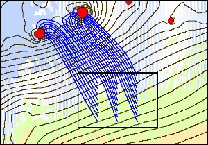 |
Display of the flow lines, generated by the program MODPATH
Module TIN is used for simulation of the surface with the help of triangulation irregular network. The network is created by connecting of set of individual points, located in three-dimensional space, by the sides of triangles. The surface is represented by the set of triangular faces. TIN can be used for imaging of surfaces of different geological bodies or surfaces, defined by the mathematical functions. Elevations and other parameters, related to the network, can be displayed by the colored contour lines of color-filled zones. The network, created with the help of TIN, can be used for building of bodies or during the process of the finite-element model creation.
Module Borehole is designed for visualization and editing of the boreholes data. Boreholes can contain the data about the stratigraphy and/or the materials related to the test results. Stratigraphic data are used to representation of rock layers, which have been reached while the drilling. The rock layers are displayed as contacts and segments.
Segment is the layer, and the contact is the interface between two layers. Contacts and segments can be used in building of surfaces (with the help of module TIN), bodies and networks for the finite-difference models of the hydrogeological objects.
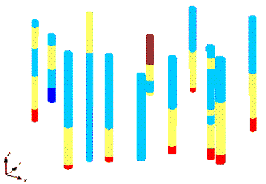 |
Rock layers display by means of contacts and segments
Module Solid is designed for building of three-dimensional stratigraphical models of the hydro-geological objects.
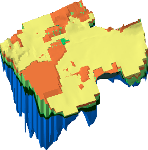 |
Three-dimensional model of stratigraphy of the hydrogeological object
Once created, such model can be used many times for generation of images of different sections. The volume of the geological object can be calculated with the help of module Solid.
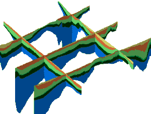 |
Čçîáđŕćĺíčĺ đŕçđĺçîâ, ńăĺíĺđčđîâŕííűő ěîäóëĺě Solid
Module 2D Mesh is applied for building of two-dimensional finite-element network. This tool provides the automatic generation and editing of the network. Such network is created during the simulation with the help of program SEEP2D, and also during the building of three-dimensional triangular network for imaging of various surfaces.
Module 2D Grid is used during the creation and editing of two-dimensional rectangular networks. Such networks are used mainly for imaging of surfaces and relief. This is realized by interpolation over the network and further shading.
 |
Image of the network, created by module 2D Grid
Module 2D Scatter Point is applied for interpolation of point data sets over the grids, networks. It supports different interpolation schemas, including the kriging. Interpolation is used during the preparation and input of primary data for the simulation.
Module 3D Mesh includes the FEMWATER program interface and is designed for creation and editing of three-dimensional finite-element network. Once created, this network can be used for specifying of the boundary conditions and parameters during the process of simulation by program FEMWATER.
Module 3D Grid includes the MODFLOW, MODPATH, MT3DMS, RT3D, NUFT, UTCHEM and SEAM3D programs interface. This module is applied for creation of three-dimensional rectangular network. These networks are designated for interpolation, building of the surfaces, sections and for application during the simulation process by the finite-difference method.
Module 3D Scatter Point is applied for interpolation of the three-dimensional point data sets over the network or the grid. Different methods of interpolation are used, including the kriging.
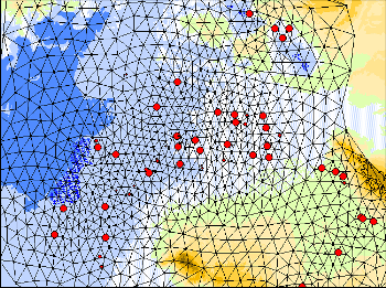
Module Ěŕđ is designed for creation of the conceptual model on the basis of GIS-objects, which include the points, lines and zones. The conceptual model is created regardless the grid or networks. This is the high-level description of the components, including the sources-outflows, boundaries of simulated area, zones of feeding and discharge by transpiration, material of zones within each layer.
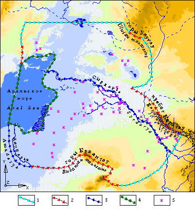 |
Schematization of hydrogeological boundary conditions of Eastern Priaralye
Typical objects of GMS 3.1 simulation systems, usable for boundary condition discription: lines of representation of: 1 - heads, 2 - torrents, 3 - rivers; zones of representations of: 4 - hesds; dots: 5 - water intakes
Database Management System ACCESS. ACCESS software executes the functions of management system for the database of bibliographic descriptions of the documents concerning the Aral region problems. At the present time the database serves mainly the internal users of the system. It is supposed that in future the access to the data will be arranged through INTERNET as well.
ACCESS allows supporting of the relational data models. It provides the different forms for data input into the database, data output in the form of reports. Forms' and reports' designing is executed with the help of wizards, builders and queries. Additionally there are available so called autoforms and autoreports. ACCESS allows using of three programming languages:
In order to arrange the data operations from INTERNET, the files of special type - Data Access Pages – are used in ACCESS 2000. They provide the user with the access to the data and the operations with the data; they allow searching and structuring of data in information networks. In their functions, Data Access Pages are similar to the classic forms and reports. Special package - Data ACCESS Page Toolbox - is available in ACCESS 2000 for their building. HTML-pages, which contain the dynamic links to the data, are created with the help of this tool. ACCESS is the part of the wide-distributed software package Microsoft Office. The detailed description of ACCESS software can be found in numerous publications, for example in [Dubnov P.Yu., 2000] and others.
Program for WEB-pages design – FRONTPAGE. FRONTPAGE software is used for designing and supporting of WEB-pages, which contain the data concerning the hydrogeological conditions of the Eastern Priaralye and intended for free distribution.
WEB-pages are created with the help of special formatting language, which is called Hypertext Markup Language (HTML). These pages can contain text, images, sounds, animation and video. HTML language can be read at any computer, if this computer has the installed WEB-browser – the program for conversion of HTML language instructions into the visual form of multimedia WEB-document. WEB-pages are usually combined in groups, called WEB-sites. Surfing from one page to another is realized by clicks on hyper-links, which can be represented by words or images. After clicking the hyper-link you can proceed to another WEB-page.
During the WEB-site designing, the objectives of its creation are defined, its structure is planned; text is composed, graphics and other elements are selected for each page.
At the beginning stage of WEB-site designing, during its objectives definition, it is usually clarified for whom this site is created, what information is supposed to be published on it, what resources (money, time) can be spent for its design and exploitation.
During the site structure designing, the data are clarified, which are supposed to be published. After that the data are divided into the logical groups. Amount of WEB-pages for each subsection is determined as well as the information, which shall be contained by each page. The system of pages relations with the help of hyper-links is planned.
Then the work over the WEB-page design is executed (determination of publication style, hierarchy style, font size, graphics preparation, etc.). After the design finishing the works over the site creation with the help of FRONTPAGE shall commence. This program includes three main components, designed for creation and servicing of the WEB-site: WEB-server, FRONTPAGE EXPLORER and FRONTPAGE EDITOR.
FRONTPAGE stores WEB-sites on the computer, where the program-server is running. WEB-site is created and its structure is modified with the help of FRONTPAGE EXPLORER. WEB-pages creation is executed with the help of FRONTPAGE EDITOR.
The detailed description of FRONTPAGE usage can be found for example in [Microsoft FrontPage 98. Step by step, 1998 (in Russian)].
Service programs. Service programs realize the functions of data exchange between the individual components of the system, as well as the reference-information servicing of internal users. These programs provide the effective work of the users with the system during the geoinformational-mathematical simulation.
Hardware complex. System of the geoinformational-mathematical simulation of the Eastern Priaralye hydrogeological conditions is located in the Institute of Hydrogeology and Hydrophysics of the Ministry of Subsurface Preservation of the Republic of Kazakhstan in the Laboratory of simulation and hydrodynamics. The applied hardware complex consists of one server and five workstations. The workstations' functions are executed by personal computer PIII-PIV, with CPU frequency from 800 MHz to 3.0 GHz, and RAM - 128-512 Mb. Server – HP NetServer LC 2000 PIII. All computers are connected into the peer-to-peer local network with the bandwidth of 100 Mb/s. Additionally this complex includes several printers (color and black-and-white) of Ŕ4-Ŕ2 formats, and the color inkjet plotter HP DJ 500 of Ŕ0 format. Connection to INTERNET is realized through the dedicated line.
Geoinformational-mathematical models, creatable as the basis for rational utilization control system of water resources, can be exploited a long enough time. Considerable volumes of operative data concerning simulation and the processes taking place in this complex are introduced into it. The last-mentioned are repeatedly used for the detailed description of the model, supporting its adequacy with changing conditions of nature. Initial data for creation and exploitation of the model are presented in graphic and semantic form. After the corresponding processing they are converted into massives of parametres, which form in-machine informational base of the mathematical simulation system. The results of simulation in its turn are converted from numerical form into graphic one, suitable for the further analysis and utilization by the specialists. Taking into consideration before-mentioned, it seems that informational basis of geoinformational-mathematical model in general case is bound to include into itself three components:
Organisation of data exchange between components, using special programming means, is necessary.
 |
Structure of informational base of the system of geoinformational-mathematical simulation
It is supposed that complex is bound to work in the following way. All semantic information concerning object and processes taking place on it is introduced into the system (from keyboard, from other informational systems, from systems of automated monitoring). To them belong correspondingly structured descriptions of wells, prospecting pits, borewells, etc., results of various probings, occasional measures, stationary observations, etc. After preliminary processing this information is introduced into base of semantic data. Cartographic information, with help of the special equipment, is introduced into graphic data base. Massives of hydrogeological parametres are forming in accordance with the assigned spatial-temporal schematization and with taking into consideration of the programming means used on the base of the information stored at the bases of semantic and graphic data. The last-mentioned are introduced into base of models and are used during the simulation process, the results of which in digital form are collected at the same base. Massives of parametres, with help of the special programming means, are converted into formates of graphic data base, edited, and then used for the construction of different combined maps. Specialist-modeller is bound also to have the possibility to review initial semantic data, to edit them, to transform into graphic form, more suitable for analysis, in order to control effectively the process of simulation. Functional structure of the system, capable to realize basic principles of geoinformational-mathematical simulation of hydrogeological objects, is given on Figure.
 |
Functional structure of the system of geoinformational-mathematical simulation
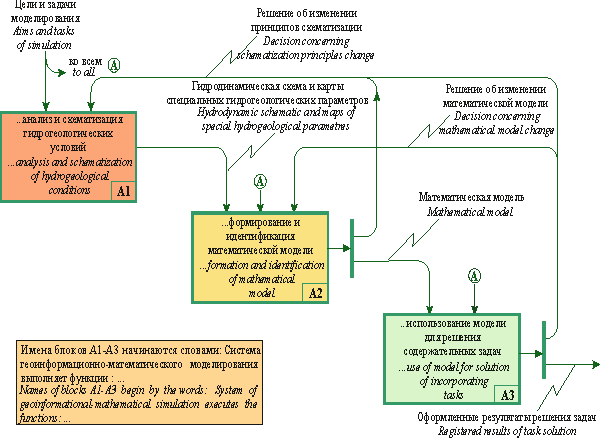
Analysis and schematization of the hydrogeological conditions (Ŕ1) are bound to be executed with regard to the aims and tasks of simulation. Hydrodynamic schematic and maps of special hydrogeological parametres, which are used as initial data for the formation and identification of the model (Ŕ2) are created in the result of this. Aims and tasks of simulation also influence onto procedure of formation and identification of the model. As a result it is created calibrated mathematical model, which is used for the solution of incorporating tasks (Ŕ3). The decision concerning hydrogeological conditions schematization principles change and repeated execution of the procedure Ŕ1 can be taken during the process of model identification. The results formed are bound to be as the result of solution of incorporating tasks on model (Ŕ3). Instead of this a decision can be taken concerning change of the mathematical model and (or) the principles of hydrogeological conditions schematization.
Structure of functions of analysis and schematization of hydrogeological conditions is given on Figure.
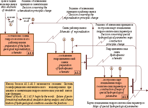 |
Ŕ1. Structure of functions of analysis and schematization of hydrogeological conditions
It is necessary to organize collection of initial information, its estimation, preparation and input of semantic and graphic data into the base for the realization of the function Ŕ1.1.
Introduced into graphic and semantic data bases information, after its checking and editing, is used for the first turn for the study of hydrogeological conditions. In this case approximate boundaries of the territory simulated are defined. Its regionalization is made by the conditions of regime formation of groundwaters and water balance character of boundaries and boundary condition, lithological composition, etc. As a result is the hydrogeological regionalization schematic and its description. The regionalization is executed obligatorily with taking into consideration of aims and tasks of simulation.
The system is bound to provide the possibility of execution by hydrogeologist-modeller of detailed analysis of the hydrogeological conditions of the territory investigated for the realization of functions of A.1.2. The task of schematization – to simplity maximally the hydrogeological conditions, to consider only those factors, which substantially influence onto processes imitated. In this case it is of need to use the special criteria, allowing to estimate qualitatively and quantitatively the tolerance of these simplifications, to calculate the error which in this case appear [Gavich I.K., 1980; 1988]. On this stage model of process imitated is bound to be selected, and field of geofiltration is bound to be schematized, and the hydrodynamic schematic and its description becomes the result.
Simulated field schematization process can be conditionally divided onto the following stages:
The system is bound to provide the construction of complex of special hydrogeological parametres map in automated regime for realization of the function Ŕ.1.3. Procedure of its construction and approach to automatization in considerable degree depends from map contents. It is possible to consider with the known share of conditionality that maps reflect the properties of water containing rocks (coefficients of filtration, gravitational water losses, sorptive capacity, distribution, etc.); groundwaters properties (pressure or absolute mark of level, temperature, concentration of components diluted in water, etc.), processes of interaction of the simulated object with environment (infiltration of atmospheric precipitations, evaporation from open water surface, discharge though spring drainage, exploitation of groundwaters by water-intaking constructions, drainage, etc.), and also certain integral indices characterizing the properties of separated layers (water conductivity, elastic water losses of bed, capacity, etc.). Isolines are used for mapping of values of parametres which are changing in space continuously and regularly.
The zones are used for mapping of parametre values, which can be changed jump-like. The values of the parametres are connected with every zone, and intervals of their allowable changes are given. Maps of parametres are constructed for each layer, isolated in section.
Functions of formation and identification of mathematical models are shown on Figure.
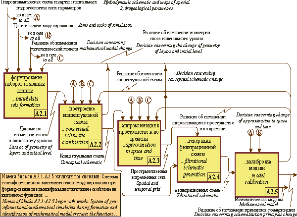 |
Ŕ2. Structure of functions of formation and identification of mathematical model
Mathematical model of the hydrogeological object investigated is liable to be formed and calibrated in the result of execution of these functions.
Initial data sets formation – this is the operation of transformation of collected initial data into formats, usable by the mathematical simulation system. The demands to the formats depend of the peculiarities of mathematical simulation system, entering into complex. Data as of geometry of isolated during schematization beds, information as of observation points, in which coincidence of calculated on the model parametres, measured as of the results of field or laboratory works, is controlled, and also expenditures of exploitational wells, water levels in water reservoirs, and watercourses, concentrations of polluting agents in springs, etc., are liable to be included into the set. Initial data sets formation is bound to be made in automated regime with the help of specially developing for this aim programming means.
Conceptual schematic construction. The conceptual schematic is the mapping of hydrodynamic schematic by the means of mathematical simulation system. As hydrodynamic, it includes image in plan and section of the conceptual schematic, and also the image of maps of hydrogeological parametres in formats of the systems of simulation.
Numerical models of maps of hydrogeological parametres stored in graphic data base, are due to be transformed into formats of mathematical simulation system. If the necessary factographic information is absent in data base, then it on this is stage is bound to be replenished by expert-modeller on the ground of analysis of oblique information or adopted as of analogy with other, more studied objects, etc.
Approximation as of space and time. It is necessary, for transformation of conceptual schematic into filtrational one, to present grid approximation of simulated field in space (in plan and in section), to execute approximation of the simulated process in time and to reflect onto spatial-temporal grid all the initial data (conceptual schematic, maps of hydrodynamic parametres and sets of initial data).
Approximation as of space is due to be executed, taking into account the peculiarities of programming means chosen and method of solution of differential equations, describing the process imitated. Approximation of the simulated field in section is made on the ground of information about geometry of isolated layers (using absolute markings of earth`s surface and bottoms of isolated layers), represented in conceptual schematic, or executed by modeller in just the same way as for planar grid (i.e. it is described using above-mentioned parametres).
The results of schematization – time, which is considered as the beginning of the process of simulation, quantity and length of stress periods are used for execution of the approximation of simulated process in time. Each stress period, in case of necessity, is bound to be divided onto some quantity of steps for the registration of task solution results on each of them.
Filtrational schematic generation. Filtrational schematic represents the mapping of conceptual schematic onto spatial and temporal grids. Filtrational schematic is liable to be generated by the system automatically. In this case interpolation is made into cells of spatial and temporal grid and the results are given in formats, usable by simulation program chosen. Formal control of iniitial data and their editing in case of finding out of mistakes is bound to be executed using special programming means. Filtrational schematic generation and parametres interpolation into nodes of spatial and temporal grid finish the stage of mathematical model creation.
Model calibration. Calibration is the most important stage of simulation and is executed for the model adequacy proof with natural conditions. Sometimes the term «calibration» is replaced by the other term «identification of the model by way of solution on it of a series of reverse tasks». Model parametres matching is liable to be executed during identification conducting procedure. Areal feeding, filtration coefficients, elastic and gravitational water loss, etc., are such parametres for hydrodynamic tasks. The coefficients for the task of transfer of component dissolved in water – coefficients of hydrodynamic dispersion, sorplive capacity, concentration of dituted in water components directly in source (if it is not possible to measure it experimentally), etc. Reverse task solution quality is bound to be estimated as of a series of criteria and limitations – dynamic, diagnostical, physical likelihood, which are defined by the expert-modeller (Ăŕâč÷ Č.Ę., 1980, 1988).
Model calibration functions structure is shown on figure.
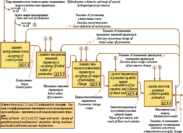 |
Ŕ 2.5. Model calibration functions structure
Usually regime or prospecting wells are used as control points. The modeller is due to have the possibility to choose as control points all or only those from them, which he considers as reliable. It is necessary, before beginning of model calibration, to assign to matched parametres some initial values. The most these values will be nearer to real ones, the more will be the probability of success. Initial values of matched parametres are bound to be assigned as of the results of experimental determinations – field and (or) laboratory. In case of absence, expert-modeller is liable to assign them on the ground of oblique data, use of the method of analogs, etc. Instrumental means are bound to provide access of modeller to the information necessary for adoption of decision, present it in form, suitable for perception and analysis.
Ranges of possible changes of values of parametres matched are assigned for the estimation of the degree of geological coincidence of model to the real object. Initial values of matched parametres and ranges of their change are due to be defined on the stage of conceptual schematic creation. They can be changed, added and made more precise on the stage of the realization of the function Ŕ2.5.2 and Ŕ2.5.3. The zones for which the values of parametres will not be changed during the process of simulation are isolated and assigned.
Further the direct task is due to be solved. Matching quality is estimated by coincidence of calculated values of dynamic functions (absolute markings of levels and flow discharge) with assigned values in control points. The corresponding decision is taken by the expert in the result. Under unsatisfactory result, for example, ranges of parametres change, configuration of zones of its assigning, which are considered as known and constant at the process of solution of the present task, etc., can be corrected. After this, the solution of the direct task and estimation of the results are repeated. Model calibration – very labour-consuming procedure. But its complete automatization does not always provide for the production of acceptable result. By our opinion, as the most perspective is optimal control methods application in conjunction with expert approach [Veselov V.V., Panichkin V.Yu., 1999, 2001, 2002]. The sense of it is in the following. Assigning of initial parametres of model, intervals of their possible changes, and also approximate calibration of model is made by expert. Automated system is liable to represent to him for this aim all the necessary information in suitable form, and also to provide realization of one or another solution adopted. Fine calibration is bound to be executed automatically with application of the optimal control methods.
The process is liable to be repeated up to reception of results, satisfactory from point of view of expert. If it is impossible to get acceptable values of matching parametres, then solutions can be taken, for example concerning grid approximation of simulated field, introduction of changes into conceptual model, into contolling parametres, principles of schematization of hydrogeological conditions, etc.
Solution of the task on formed and calibrated model is made using programming means, entering into mathematical simulation system. These means are due to provide the solution of differential equation, describing the process imitated, by numerical method, calculation of balance components of groundwaters flow and transport of component dissolved in them, final preparation of results.
Results of solution are due to be presented in graphic form, in the form of maps of isolines and (or) zones, sections, images of surfaces in isometry, images of three-dimentional cartograms. Programming means are bound to provide the mapping of dynamic parametres assigned by outer and inner boundaries of model in the form of different graphs – separated and (or) juxtaposed.
The possibility of export of results of simulation into formats, usable by geoinformational systems, graphic editors, automated systems of design, specialized graphic programs (for example, SURFER) for the construction of various juxtaposed maps, reflecting initial data, used for the creation of model and results of simulation, must be obligatorily.
 |
|
 |
|||||||||
Previous |
Next |