|
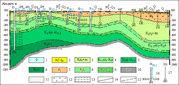
Schematic hydrogeological profile by the line II-II
Water-bearing horizons and complexes of depositions: 1 - Quarternary; 2 - Upper Pliocene - Lower Quarternary; 3 - Upper-Turon Senonian; 4 - Upper- Albiam-Cenomanian; 5 - Lower-Middle-Albian, Aptian; 6 - Neocomian. Water confiing bed depositions: 7 - Eocenic; 8 - Lower-Turon; 9 - Lower- Middle- Albian. 10 - groundwaters of the zone of opened fracturing of Paleozoic rocks. Lithological composition of rocks: 11 - mostly sand; 12 - clays; 13 - aleurolites, argillites with intercallations of clays. Boundaries of horizons and complexes: 14 - established, 15 - supposed. 16 - hydrogeological bore hole. Numbers: above - digits; from left - water mineralization, g/l; water temperature, c; from right - output, l/sec depression; below - depth of bore hole, m; Arrow corresponds to head of groundwaters, digit near arrow - absolute sign of piezometric level, m. 17 - geological bore hole. Digits: above -number, below - depth, m.