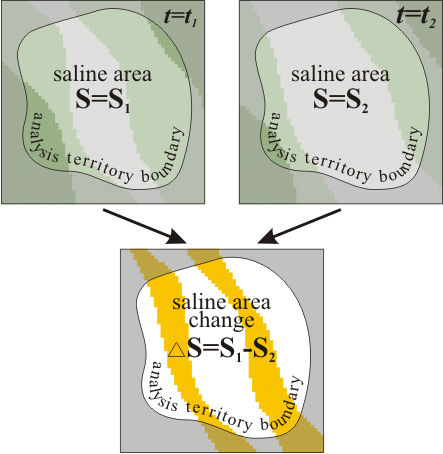
Formal task is reduced to the soils salination areas calculation at the limits of area prescribed for precise temporal moments and to the comparison of them.
Task formulation
|
|
|
Saline soils areas change dynamics estimation under influence during exploitation of Akdalinski irrigational massif is only made for adjoining territories. Calculation temporal period – 20 years (from 1990 to 2010). The territory investigating is situated in arid zone, where evaporation is predominated over atmospheric precipitations. The estimation is made with use of methods of remote sensing and that of GIS-technology.
Formal task is reduced to the soils salination areas calculation at the limits of area prescribed for precise temporal moments and to the comparison of them. |
Foundation of the method used
| Remote sensing of Earth – receiving of the information with use of apparatus, installed on air – or cosmic ships (Trifonova A., Mishchenko N.V., Krasnoshchekov A.N. Geoinformational systems and remote sensing in ecological investigations – M., 2005. – 352 pp.)
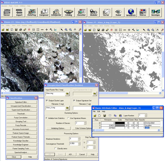
The data of the remote sensing give the large volume of information about territory. But this information is the primary and it demands the further processing. Processing task consists in interpretation of received data for the production of information concerning the properties of the objects investigated. They traditionally isolate some stages of data processing during remote sensing. As an advantage of remote sensing data use for salinated soils areas change dynamics estimation is the relative cheapness of this method. The basic disadvantage – impossibility to precisely identify the zones of salinated and non-salinated soils. It is possible to increase the reliability of results on base of combination of remote sensing, of terrestrial investigations and detailed expert analysis of the oblique information in whole as for the object investigated. Utilization of GIS-technologies is advisable for information analysis. Space photos made in visible part of the spectrum from spaceship are used for calculation of soils salination dynamics calculation. Two zones corresponding with saline and non- saline soils must be isolated on the pictures. The special method of images processing – classification, is used for this aim. For its automation it is advisable to use the pack of data processing of remote sensing of Earth ERDAS Imagine 9.1. |
|
|
Technology
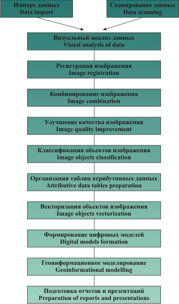
Technology developed includes the following steps.
1. Collection and preparation of the available original data.
2. Choice of space images of the region of massif irrigated and of adjoin territories.
3. Processed materials analysis.
4. Execution of field routes of investigation.
5. Final analysis of materials collected.
1. Collection and preparation of available original data includes digitalization and geographical surveying of the cartographic materials by GIS means. Factographic data as for wells, prospecting fits, point of probing of surface waters and so on are presented in the form of Tables. It is executed the connection with all graphic objects of GIS tabular (attributive) information.
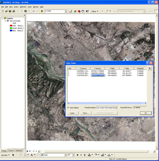
Surveying of images with help of ArcGIS
Quantity of classes Number of Classes (in this very case – two classes), number of iterations Maximum Iterations and threshold of convergence Convergence Threshold are prescribed during the process of the procedure to each class. On the next stage of processing this or that meaning of attributive index is connected with every isolated class. Then, using Edit/Add Area Column, it is possible to calculate area corresponding with each isolated class.
Classification of geoimages by ERDAS means
2. Choice of space images of the region irrigated massif and adjacent territories, their correction and geographical surveying is made with the help of ArcGIS 9.3 и ERDAS Imagine 9.1. . There are used images of large scale made into various temporal moments. They must be of the same type, for example, of visible range. As the most qualitative must be images of high grade without cloud cover. It is necessary during selection to take into consideration that soil salination on images is reflected only in case of salt covers appearance on the surface. In dry state saline soils are much clear in comparison with non saline, and in wet state – they are much darker. Therefore it is advisable to select images produced in spring or summer seasons of the year.
3. Analysis of materials collected is made with use of ArcGIS 9.3 and ERDAS Imagine 9.1. Pretreatment of space images is made by method of classification, at the process of which are isolated saline, non-saline zones. Place of observation points, and soils probing are defined, field routes are planned.
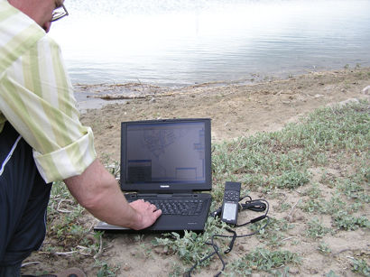
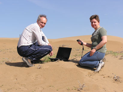
4. Execution of investigations of field routes is made with utilization of global positioning system (GPS) and GIS prepared earlier, installing on mobile computer. It allows to do quick search of planned on the territory points; to execute their picturing, description and probing.
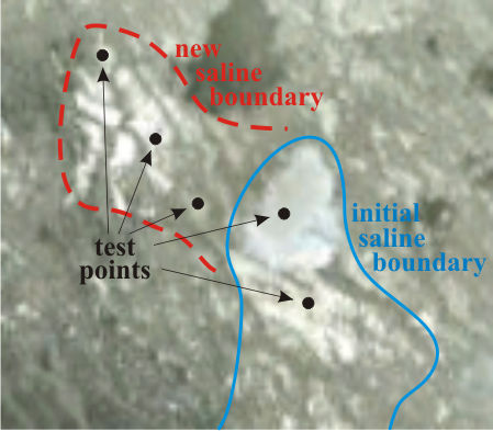
5. The final analysis of materials collected presupposes the execution of repeated processing of space images. On the best of information produced during the process of field surveying execution, are made more precise the isolation of zones corresponding with saline and non-saline soils. Repeated classification of space images is executed. Expert correction of the isolated areas boundaries is made with use of various maps – topographic, geomorphologic, those of bedding depths of ground waters layers and so on.

[Home]
[Contents]
[Links]
[Authors]

Previous
Next