DEVELOP THE METHODOLOGY FOR THE USE OF MATHEMATICAL MODELING, GIS AND REMOTE SENSING TECHNIQUES FOR SOLVING URGENT HYDROGEOLOGICAL PROBLEMS IN THE REPUBLIC OF KAZAKHSTAN

Develop the methodology for assessing the negative impact of irrigation on the environment with the use of remote sensing and GIS technologies in the Republic of Kazakhstan

4. Development and description of negative influence estimation methods of irrigation onto environment with application of remote sensing methods and GIS-technologies

4.2 Agricultures distribution schematic specification methods by the methods of remote sensing

Agricultures distribution schematic specification procedure is necessary for the correct schematization of hydrogeological-meliorative conditions during the process of mathematical model creation. In order to propose groundwaters feeding map is necessary to differentiate areas, occupied by rice and other agricultures.

Agricultures distribution schematic specification is made by means of ArcGIS, MapInfo and ERDAS. There are used for this the space images, which are analyzed together with existing schematics of agricultures distribution, with topographic maps, and results of field investigations results on testing areas and so on covered with water rice checks are precisely seen on space images, executed during second half of May.

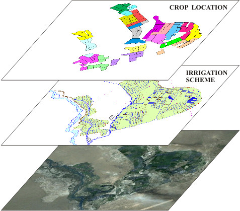
For automation of agricultures distribution specification procedure, all the before-indicated graphic and semantic data must be digitized, and surveying of cartographic materials and space images must be executed in geographical system of coordinates, and the corresponding attributive information must be bound with graphic data. Space images are bound with means of ArcGIS è MapInfo. It is executed at the care of necessity remove of clouds, orthotransforming, and so on.

Isolation and mapping of distribution areas of these or those agricultures is executed by expert route. ArcGIS or ERDAS classification instruments are used for this aim – assignment of criteria for division onto classes and their quantity is defined by way of expertise. After mapping of areas with different agricultures, with help of ArcGIS or ERDAS instruments are calculated areas of isolated zones, then the map of agricultures distribution is prepared.

Previous chapter
[Home] [Contents] [Links] [Authors]

Previous