DEVELOP THE METHODOLOGY FOR THE USE OF MATHEMATICAL MODELING, GIS AND REMOTE SENSING TECHNIQUES FOR SOLVING URGENT HYDROGEOLOGICAL PROBLEMS IN THE REPUBLIC OF KAZAKHSTAN

Development of the procedure of systems preparation for mutually connected variously scaled mathematical models of artesian basins of the Republic of Kazakhstan

4. Programming means used for the creation of the system of interconnected variously schaled mathematical models

Modern systems of mathematical modeling are presupposed for imitation of various processes, taking place on the hydrogeological object – groundwaters filtration, migration of soluble in water components, water-, salt transfer at the aeration zone, and so on. There are entering into their composition the special programming means, allowing to reproduce the interaction of the investigated object with environment, and also the influence of differently-directed technogenic factors.

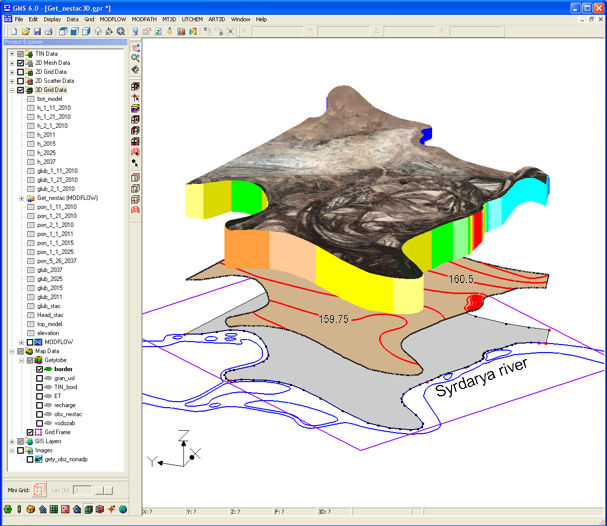
As the most effective and universal system for creation of constantly working models is GMS 6.0 (Groundwater Modeling System), developed in Brigham Young University, USA. It is presupposed for groundwaters movement modeling and for transport of soluble in water components at the zones of complete and incomplete saturation and includes various means of conceptual modeling, of automated identification of models, description of flow lines, of stochastic modeling, of geostatistics, of visualization of modeling results in plan and in section, of grids three-dimensional models constructing of stratigraphy, of two-dimensional and three-dimensional generation and of other components. The models can be created on the base of orthogonal and triangular irregularity of grids. More detailed description is given on the official site of the developer.

Visual FoxPro 6.0 – this is the medium of programming, including into its structure the means for control of the data and also the dynamic language of programming with complete set of functions. In order to ensure maximal productivity means of visual development of supplements and for preparation of data bases for desktop are supplied. It can be used for writing not only of cliental supplements but also for web-supplements and for inter-formal programming provision.

Visual FoxPro 6.0 database management system allows to work with different types of data, to create interrogation and representations of any degree of complexity, to work out remote data with help of various means of access (PDBC, Connections, ADO, RDO). ). It is possible to create programs both with utilization of object-oriented programming, and also with the old technology of module programming. As the basic advantages of FoxPro 6.0, are accessibility, simple utilization, presentation of documents in Russian and large experience of its use during hydrogeological data bases creation.

Now more latest versions of FoxPro 6.0 are accessible.

As the most universal geoinformational system is the ArcGIS 9.3 system, representing the group of programming products of the company ESRI (USA) – one of the leaders of the world's market of geoinformational systems. ArcGIS 9.3 is used for the solution of problems in various fields of activity – in land's cadastre and in land management, in oil and gas, ecology, water resources, mineral resources utilization, remote sensing, geodesy, map preparation geography, agriculture and so on.

It possesses with large functional possibilities both in case of original data preparation for systemic creation of variously-scaled models of hydrogeological objects, and also formulation and analysis of modeling results.

ArcGIS 9.3 can be used for execution of spaced analysis, based on data in raster formation and in the form of triangular grid. There are three-dimensional visualizations and representations of data changing in time, and also visualizations and analysis of data, collectable in real temporal regime. It allows to execute the complex statistical analysis of data, presented in raster format, and to convert the data from different GIS-formats, to vectoraise automatically the material scanned.

Effective storing and use of various types of data, the possibility to define the rules of behaviour of space of interconnected geophysical objects and objective classes, and also topology rules, and the function of geobases editing by many users makes ArcGIS 9.3 as indispensable during work with large volumes of various information including that which is unstructured. Now ArcGIS 10 is accessible (http://www.esri.com).

MapInfo 10 combines the advantages of information processing which have data bases and clearness of maps, schematics, graphics. It allows directly use or import files of various formats. There are present possibilities of direct access to remote data bases (Oracle, SQL Server); of joining of maps, and legend creation for any layers of map, and creation of thematic maps for effective analysis of data, including three-dimensional maps, thematic maps of raster surfaces and maps-prisms; preparation of searching inquires of any degree of complexity as for certain files. It is possible to open the associated with objects maps, the files or to go through URL-addresses directly from Map window. MapInfo 10 has universal set of means for drawing and editing, allows to prepare the professional report in tabulated data. Possibility of map projection change during digitalization of input data is its exceptional peculiarity.

Previous chapter

[Home] [Contents] [Links] [Authors]

Next chapter

Previous

Next