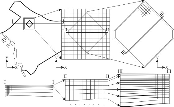
The systems of differently scaled models is expediently to use in cases when it is impossible by different causes (insufficiency of original data, technical complexity during realization, deficiency of the material resources or time) to create the detailed model of the whole region under investigation. In this case we are limiting by the creation of the detailed model only of the most important part of the territory under investigation, for example of the polluted ground waters aureole distribution part of the water intake territory, of the area on which drainage is projected and so on.
|
Structure of models system structure of hydrogeological-meliorative conditions of Bakhbakhty area of Akdalinsky irrigated massive
The regional model is created for taking into consideration of the regional factors, producing considerable influence onto the process imitated. The regional model scale can be considerably less than the scale of the local model. During its preparation, it is often used the more rough schematization of the hydrogeological conditions in plan and section, and also the larger step of grid approximation of the region modeled. Results of the solution received on the regional model are assigned as of boundaries of the local model.
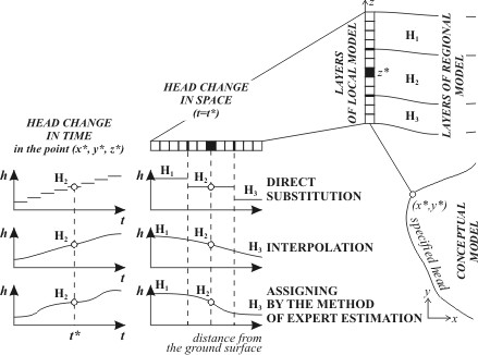 |
Boundary conditions assigning
Utilization of the systems of variously-scaled mathematical models of hydrogeological objects allows to save time, and material resources. Practical realization of such approach has certain problems which with considerable degree of convention can be divided onto theoretical, methodological and technical ones.
Theoretical problems are basically connected with the choice of the rational schematization of the hydrogeological conditions in plane and section, with assigning of boundary conditions for the regional and local models, and also with the choice of the type of the process imitated.
Methodological problems are defined by insufficiency of effective utilization of the present possibilities of programming and instrumental means.
Technical problems оare conditioned by incomplete functional possibilities of programming means and by insufficient technical character of instrumental means – low high-speed response, insufficient volume of operative memory or memory on outer devices, non-effective means of input / output of graphic data and so on.
Assignment of boundary conditions as of outer boundaries of local model is the basic difficulty during creation of the system of variously-scaled models. In a general case, boundary conditions coordination must be made certainly also by head and discharge. Sometimes it is enough to execute coordination of boundary condition only by head. Choice of hydrogeological conditions schematization principles in plan and in section for local model is an important problem. They must correspond with the aims of modeling and peculiarities of schematization of hydrogeological conditions executed for the regional model.
 |
|
 |
|||||||||
Previous |
Next |