
ARTESIAN WATERS – ground waters, situated in more or less deeply deposited aquifers among water-resisting layers and forming basins. Artesian basins are under head because of the fact that they being stripped by wells (artesian wells) are raising in them higher than the roof of aquifer and under enough height of the head are flowing out onto the day surface or are gusting. (Makkaveev A.A. Dictionary of hydrogeology and engineering geology. M., 1971, 216 pp.)
|
Hydrogeological section of artesian basin
Depositions: 1 – Quaternary (loessial-like loams and sands with groundwaters); 2 – Neogenic (sands, clays, marls); 3 – Cretaceous (chalk, marls); 4 – Cretaceous (sands) – artesian aquifer; 5 – Jurassic (clays); 6 – Jurassic (sands) - artesian aquifer; 7 – Paleozoic; 8 – Precambrian, crystalline rocks (granites, gneisses); 9 – self-effusive wells; 10 – wells which are not self-effusive; 11 – head waters level.
Under intensive exploitation of ground waters deposits confined to artesian basins, depressive cones appear, the size of which can attain many tens of km. Water intakes work influence can be distributed far the boundaries of Kazakhstanic territory.
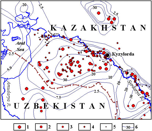 |
Map of predicted depression of groundwaters level of aquiferous complex of Upper Turon-Senonian depositions (as of the state for the year 2040)
Exploitation resources of deposits of groundwaters in sum of categories and productivity of water intakes, working on non-approved reserves (liter/sec): 1- more than 100, 2 - from 50 to 100, 3 - from 30 to 50, 4 - from 10 to 30, 5- from 1 to 10. 6 - isolines of predicted depressions
In its turn the work of water intakes, situated in adjoined states, can produce the considerable influence onto hydrogeological conditions in near the boundary zone of Kazakhstan.
Reciprocal influence of exploitation of many water intakes can be estimated only by mathematical modeling methods. In general case the region modeled area must include the whole zone of water intakes influence. Therefore the size of the region modeled can be vast. Taking into consideration the restriction of the resources of programming-technical means, it seems as impossible to create the detailed model of the whole artesian basin. Simplified models have the restricted region of application. In order to solve this contradiction, it is offered to use for modeling of hydrogeological conditions of artesian basins the procedure involving the creation of the system of interconnected, differently scaled models. Such procedure have been worked out at the Institute of hydrogeology and geoecology named after U.M.Akhmedsafin.
 |
|
 |
|||||||||
Previous |
Next |