Hydrogeological conditions of coastal zone are in detail described in [Sydykov Zh.S., Golubtsov V.V., Kuandykov B.M. Caspian sea and its coastal zone (natural conditions and ecological state). Almaty, 1995, 211 pp. (in Russian)], and also in [Bochkareva V.A., Sydykov Zh.S. et al. Groundwaters of Pricaspian depression and its eastern framing. Almaty, 1973, 288 pp. (in Russian)], [Sydykov Zh.S., et al. Pricaspian hydrogeological region // Hydrogeology of USSR. Western Kazakhstan. Moscow, 1971, Vol. 35. pp. 97-122. (in Russian)], [Sydykov Zh.S., Mukhamedzhanov M.A. et al. Hydrogeological and engineering-geological conditions of Caspian sea shore zone and forecast of their changes // Reports of NAN RK, 1995, ¹ 6, pp. 43-55. (in Russian)]. Below their short characteristic is given.
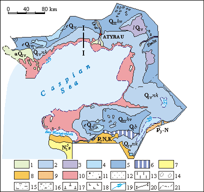
Groundwaters are contained in depositions of Quaternary, Neogenic, Cretaceous, Jurassic and Paleozoic ages. Horizon of groundwaters on the territory described is everywhere subjacent by massive depth of clays of Quaternary age, which are the regional aquiclude. It is considered that considerable leakage of any value over aquiclude does not taken place. Because of this description of underlaying below aquifers and aquiferous complexes is not given here. Schematic map of groundwaters of the coastal zone of Kazakhstanic part of Caspian sea is given on the Figure [Sydykov Zh.S., Golubtsov V.V., Kuandykov B.M. Caspian sea and its coastal zone (natural conditions and ecological state). Almaty, 1995, 211 pp. (in Russian)].

|
Schematic map of ground waters of the Northern shore of Caspian sea
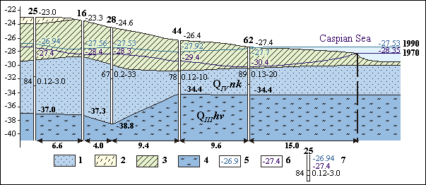
Groundwaters are confined to small-and fine-grained, sometimes clayish sands of Quaternary depositions with persistent by strike interlayers of clays. Total thickness of water-bearing depositions changes from 2-10 to 15 m.
 |
Hydrogeological section as of the line I-I
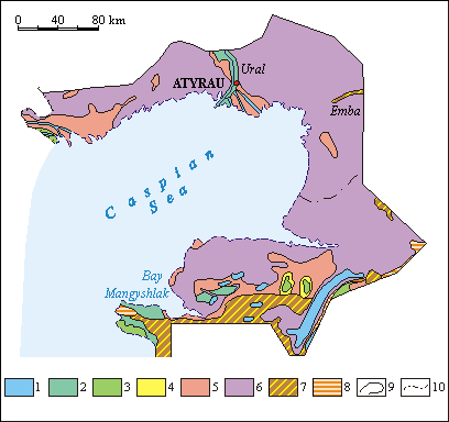
Filtrational abilities of water-bearing rocks are low. Filtration coefficients are basically situated at the boundaries from 0.1-0.2 to 3-5 m/day. Depth of accurence of groundwaters on the considerable part of coastal zone oscillates from 1-3 m, increasing up to 5-7m on the elevated areas of territory described. Groundwaters mineralization is high (from 10 to 300 g/l), chemical composition more often is chloride-sodium.
 |
Schematic map of ground waters mineralization of the Northern shore of Caspian sea
Groundwaters have unified hydraulic surface with slope, for the most part, to the side of Caspian sea and numerous sor depressions, in which groundwaters discharge is taking place. During low water period it occurs also into rivers beds. Groundwaters alimentation is taking place in the result of atmospheric precipitation infiltration, water flow from Caspian sea on the separate parts of its coastal line, and also river discharge loss during high waters. Total annual infiltration layer, in accordance with data of G.N.Kamenski, I.V.Garmonov et al. (1960), with exclusion of evaporation on the drained parts, in an average, has the value about 10 mm/year, and in littoral stretch, near Ural river valley – 3-7 mm/year. Directly in littoral zone of the sea, infiltration is equal to 6 mm/year, excluding solonchaks and takyrs (claypans), where it is near to zero. Only on the area of sinks, silted estuaries and sink holes where more permeable depositions are distributed, it is of the order of 20-30 mm/year. Average value of infiltration in river valleys, in dependence of water content of the year, terrace hypsometry and depth to water, by data of M.P.Raspopov, G.Ya.Bogdanov, et al (1960) changes from 30-50 to 100-150 mm/year. Infiltration of high waters at pre-mouth part of akhtuba flood plain reaches the value of 160-210 mm/year.
 |
|
 |
|||||||||
Previous |
Next |