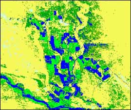
in the Bakanass part of Akdalinsky area
(26 May, 1990)
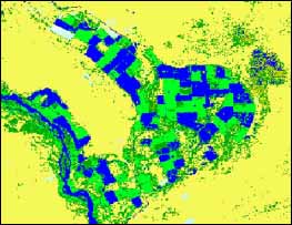
in the Bakhbakhty part of Akdalinsky area
(26 May, 1990)
in the Bakanass part of Akdalinsky area
(13 May, 2000)
in the Bakhbakhty part of Akdalinsky area
(13 May, 2000)
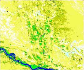
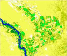
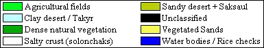
Two LANDSAT images (Figure in the chapter “Hydrogeochemical conditions”) for May 26, 1990 and May 13, 2000 were processed to assess the impact of irrigation on the hydro-ecological conditions of the Akdalinsky irrigation system and neighboring territory. Digital maps and photos of the settlements, water bodies, plants, agricultural fields, irrigated lands and topographic maps (1:200000) were utilized for decoding satellite images.
Maps of supervised classification of the study area are presented in Figures. Digital analysis of these results revealed that during a period from 1990 till 2000 the area of rice fields decreased while groundwater level still remained close to the soil surface. This led to an increase in soil salinization, a decrease in vegetation area and desertification of the irrigated area and neighboring lands.
The main drainage collector also significantly affects the environment. Inspection of the collector relief profile revealed that the altitude of its bottom and the water level in the collector at many locations are higher than the groundwater level of the surrounding area. Therefore, drainage water of high salinity flows from Bakhbakhty to Bakanass and on to the Ily River. Infiltration of this water along the collector leads to salinization of the surrounding territory.
| Results of supervised classification in the Bakanass part of Akdalinsky area (26 May, 1990) |
Results of supervised classification in the Bakhbakhty part of Akdalinsky area (26 May, 1990) |
||
|
|
||
| Results of supervised classification in the Bakanass part of Akdalinsky area (13 May, 2000) |
Results of supervised classification in the Bakhbakhty part of Akdalinsky area (13 May, 2000) |
||
|
|
 |
|
 |
|||||||||
Previous |
Next |