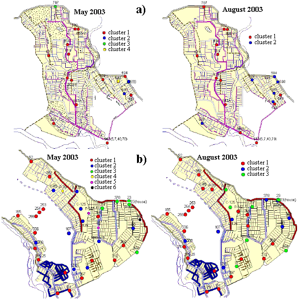
for (a) Bakanass and (b) Bakhbakty parts of the Akdalinsk irrigation system,
for the beginning (May) and end (August) of the 2003 irrigation season
Hydrogeological and chemical data were used to characterize the effects of irrigation on hydrogeochemical conditions in the study area using statistical methods. SPSS cluster analysis was performed on the spatial distribution of hydrochemical data to specify the extent of aquifer heterogeneity. This allowed the delineation of hydrological sub-regions with homogeneous properties (water bodies) in order to assess further major flow patterns, sources of groundwater contamination and hydraulic parameters. Results are presented in Figure.
|
| Clusters of wells with similar concentrations of major ions for (a) Bakanass and (b) Bakhbakty parts of the Akdalinsk irrigation system,
for the beginning (May) and end (August) of the 2003 irrigation season |
The TDS concentration was the major factor affecting cluster analysis, indicating a pseudo-linear correlation among all the dissolved minerals. Water samples with low TDS (200-400 mg/l) and chemical composition close to that of irrigation water (Ily River) belong to a cluster located in the irrigated fields and close to the irrigation canals. Clusters with TDS of 600-1000 mg/l and 1200-1800 mg/l include water samples collected in boreholes located in the peripheral parts of the irrigated land, in non-irrigated areas and close to drainage collectors.
Elevated groundwater, due to massive irrigation during the hot summer season, induces evaporation, which increases topsoil salinization in the surrounding area. After harvesting crops in September-October, hydrological and hydrochemical conditions return to a state close to that observed before irrigation, producing a so-called seasonal oscillating pattern. However, the general hydrological conditions prevail all year long in elevated groundwater.
Principal Component Analysis (PCA), which is commonly used to reveal patterns in data sets [Moon, S.K., Woo, N.C. and Lee, K.S. 2004 Statistical analysis of hydrographs and water-table fluctuation to estimate groundwater recharge. Journal of Hydrology 292, 198-209], [Winter, T.C., S.E. Mallory, T.R. Allen and D.O. Rosenberry, 2000. The use of principal component analysis for interpreting ground water hydrographs. Ground Water 38 (2), 234–246], provided insights into the characteristics of groundwater in the Akdalinsky agricultural land of the Ily River basin.
The results indicate that the dominant mode of variation in the groundwater water table is a pattern of irrigation effect, which is mostly described by the excessive water demand of the rice irrigation system.
Time series analysis of component scores indicated that most component functions can be best described with the rising and falling pattern of the groundwater hydrographs. The component scores and ground water table fluctuations associated with PC1 (1999-2002) for C-126 and C-594 are plotted in Figure.
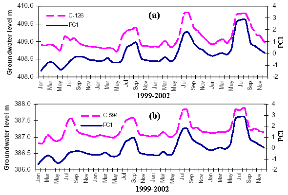 |
| Component scores and groundwater levels associated with PC1: a) well C-126; b) well C-594 |
Figure shows principal component scores and groundwater table fluctuations (1999-2002) for C-60 (0.888) and C-129 (0.803), associated with PC2.
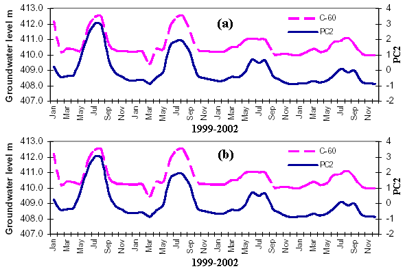 |
| Component scores and groundwater levels associated with PC2: a) well C-60; b) well C-129 |
In 2002, the area occupied by rice fields in the Bakhbakhty part of the Akdalinsk region was 4165 ha compared to 7202 ha in 1988 [Vesselov, V.V., Panichkin, V.Yu., Adar, E., Yakirevich, A., Zakharova, N.M., Miroshnichenko, O.L, Trushel, L.Yu. and Shakibaev, I.I. 2005. Geoinformation-mathematical modeling of hydrogeological conditions of the Akdalinsky irrigated land. Proc. of National Academy of Science of Kazakhstan, ser. Geology, 1, 2005, 86-95]. Results from the MODFLOW simulations indicate that decreasing this area will lead to a lowering of the groundwater level. Temporal structure analysis of water table fluctuations along with PC factor loading indicates that rising groundwater in the area is mainly associated with excess irrigation water.
The groundwater geochemistry data were also subjected to evaluation via PC analysis to investigate agricultural impact on groundwater. The analysis generated 4 factors, which together account for ~90% and ~86% of the total variances for the pre- and post-irrigation period, respectively.
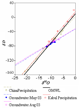
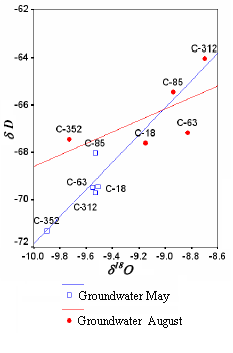
The isotopic compositions of collected groundwater samples were used to further assess the impact of agriculture on ecological conditions in the study area.
 |
 |
|
| δD-δ18O relationships for the precipitation data from Kabul (Afganistan), Wulmuqui (China), and for the Bakhbakhty groundwater samples in May and August 2003 | The δD-δ18O relationship for selected Bakhbakhty groundwater wells in May and August 2003 |
High nitrate levels are associated with enriched δ18O values, clearly indicating that significant quantities of evaporated (isotopically enriched) irrigation water infiltrate along with fertilizer nitrate to the groundwater system. The post-irrigation (August 2003) nitrate levels were higher in all the observation wells than the pre-irrigation nitrate levels (May 2003), similarly enriched δ18O values were observed for the post-irrigation period. The illustrated different δ18O-NO3 trends suggest isotopically distinct, non-point source origins, which vary spatially and temporally, due to different degrees of evaporation/recharge and amounts of fertilizer applied. However the positive δ18O-NO3 relationship indicates clearly infiltration of isotopically enriched, evaporated irrigation water along with fertilizer nitrate to the groundwater aquifer.
 |
|
 |
|||||||||
Previous |
Next |