ILI-BALKHASH REGION
Sustainable development and protection of water resources
in the irrigated land of the Ily river delta
(Project TA-MOU-01-CA21-021 funded by the USAID)
The above analyses of hydrogeochemical conditions prove that unsustainable exploitation of the Akdalinsky agricultural lands has a negative impact on the environment: raising groundwater levels, soil degradation, salinization and desertification. This is mainly caused by growing rice, which requires large irrigation norms and has a low efficiency of irrigation and drainage systems. A rational policy for sustainable land exploitation can be assessed by simulations of related processes with mathematical models.
| We started simulations for different scenarios of irrigation and water exploitation with a one-dimensional model of water flow and solute transport in the unsaturated-saturated zone (numerical code WASTR3 was developed by A. Yakirevich).
The following scenarios of water exploitation and land use were considered:
1. Rice as a major crop occupying 62.5 % of irrigated area (Soviet era policy);
2. Rice growing is reduced to 37.5 % of irrigated area (current policy);
3. Rice growing is terminated completely and replaced by other crops with higher water efficiency. |
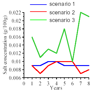 |
| Variation in mean TDS content in the upper 0-0.7 m soil layer obtained for three scenarios of simulations with a 1D model of water flow and solute transport |
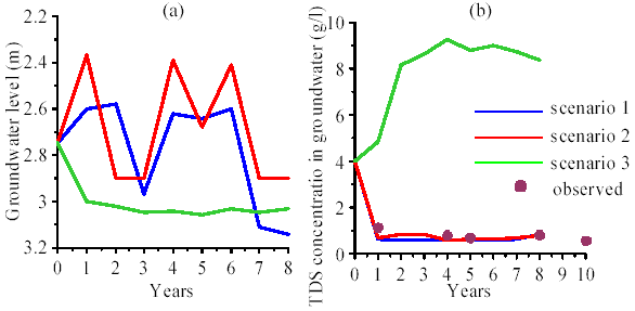 |
| Modeled temporal variations of (a) mean groundwater level and (b) TDS concentration in groundwater |
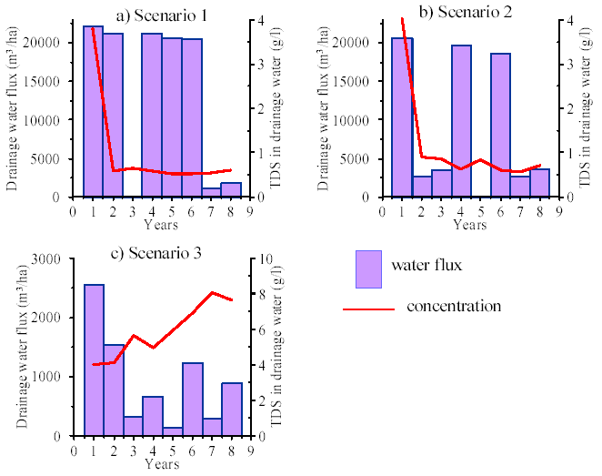 |
| Simulated drainage water discharge and its TDS concentration for different scenarios of crop rotation |
To simulate hydrogeological conditions and pesticide transport in the Bakhbakhty part of the Akdalinsk irrigation system accounting for 3D spatial distributions of state variables, the MODFLOW and MT3DMS codes (as part of the Groundwater Modeling System - GMS 4.0) were used (for groundwater flow model of the Bakanass; see [Vesselov, V., A.G. Begaliev, N.M. Zaharova and I. N. Gale, 1996. Water Resources of the Ily-Balkhash Basin, Kazakhstan. Technical Report WD/96/52, British Geological Survey, Nottingham, UK, 48p].
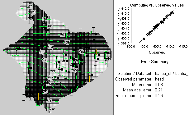
The boundary conditions of the simulated domain were specified. As a first step, we simulated the quasi-steady-state hydrogeological conditions existing in the study area before the irrigation system was constructed. A model calibration was performed for distribution of hydraulic conductivities and storage coefficients using the trial-and error procedure. The results presented in Figure show that a good agreement between simulated and observed groundwater levels was obtained.
 |
| Results of steady-state groundwater levels from simulations in the Bakhbakhty part of the Akdalinsky irrigation system before its construction (February, 1967). Green and yellow bars show that differences between simulated and observed groundwater levels are less than 0.5 and 1.0 m, respectively |
Next, based on analysis of collected information, we schematized the hydrogeological conditions for the period of 1967-2003 as follows: the network of drainage collectors and irrigation canals was introduced as a third kind of boundary condition changing with time; a first boundary condition (hydraulic heads varying with time) was specified along the Ily river border; water head was prescribed at the rice fields during the growing season; evaporation processes were simulated using the third boundary condition. Groundwater model calibration for transient conditions was performed. Good agreement between measured and simulated groundwater levels was received. In most parts of the area the error did not exceed 0.5 m.
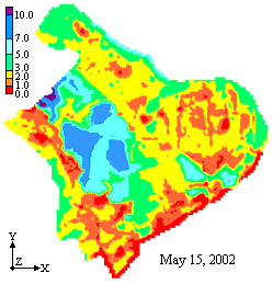
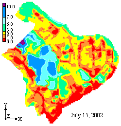
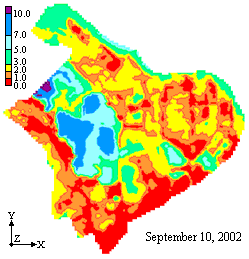
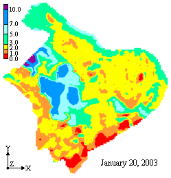
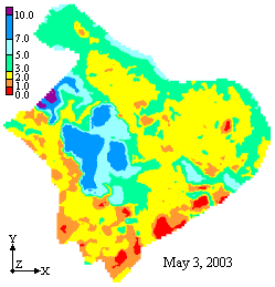
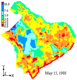
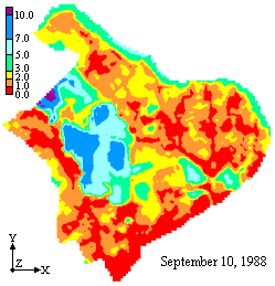
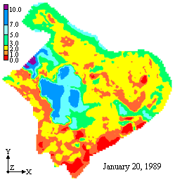
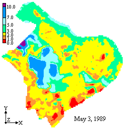
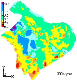
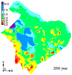
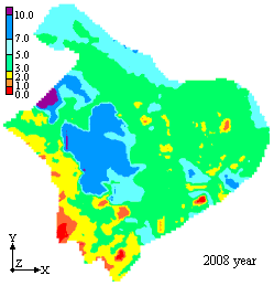
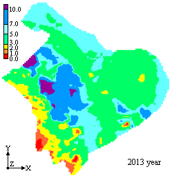
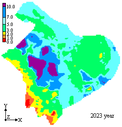
After solving the inverse problem, we performed MODFLOW simulations for three scenarios of water and land resources exploitation for the Bakhbakhty part of the Akdalinsk irrigation system: 1) rice fields with an area of 4165 ha; 2) rice fields with an area of 7202 ha; and 3) fields in which rice growing has been terminated completely.
| Simulated groundwater depth (m) in the Bakhbakhty area for scenario 1 |
 |
 |
 |
 |
 |
|
| Simulated groundwater depth (m) in the Bakhbakhty area for scenario 2 |
 |
 |
 |
 |
 |
|
| Simulated groundwater depth (m) in the Bakhbakhty area for scenario 3 in various years |
 |
 |
 |
 |
 |
|
Propanid, Saturn, Ordram, HexaChloroCycloHexane (HCCH) and other pesticides have been used in the past for weed destruction during the rice crop rotation. Concentrations of pesticides in the drainage water increase sharply during dumping of water from rice fields (usually in the middle of June and in the middle of July). Input of these chemicals with respect to total contamination is relatively low, and the risk of direct poisoning of the population through drinking water nowadays is low. However, some species of fish and other low-level organisms (planktonic sources of fish food) can die as a result of the high toxicity of these chemicals to aquatic fauna. To assess the possible effect of pesticide application on groundwater quality, we used the results of observations made during 1980-1990 to perform simulations of pesticide transport in soil and groundwater.
As a first step, the mathematical model and numerical code GLEAMS [Groundwater Loading Effects on Agricultural Management Systems, Leonard et al., 1987] was applied. Application of the following pesticides was considered for simulations: Ordram, Bolero (Saturn), Propanil, Benzex (Benzene hexachloride) and DDT (the use of DDT was terminated at the end of the 1980s). The model takes into account dynamics of climatic factors, soil and hydrological parameters and agricultural aspects.
More detailed simulations were carried out with a 3-D local model of pesticide transport. The local areal modeling domain is represented by a rectangular area located at the northern part of Bakhbakhty region.
Only one pesticide - Saturn (Bolero) - was considered. The processes of pesticide advective-dispersive transport and degradation were accounted for.
A calibrated model was used to study the evolution of pesticide distribution in groundwater. We note that the pesticide plume reached maximum depths of 8-10 m. After about 55 days the plume dissipated and the concentration dropped to less than 2 ppb (maximum admissible concentration of pesticide concentration for fisheries). Drains and collectors intercepted most of the pesticides. The calculated maximum rate of pesticide removal by drains reached 0.09 g/day/ha.
 |
|
 |
Previous |
Next |