
The approach used for this study is based on analysis and integration of field data, and detailed numerical simulations of different agricultural production and water management strategies.
 |
 |
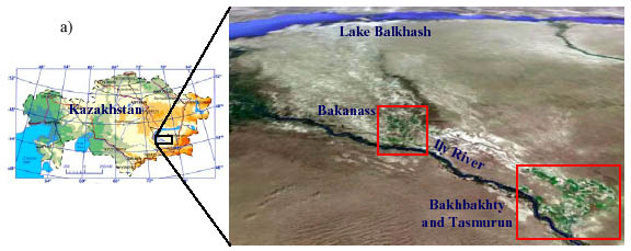
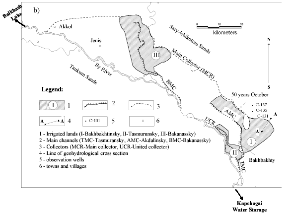
| Geographic location (a) and a schematic map (b) of the study area |
The study area is sand dune terrain located in the southeastern part of Kazakhstan. It is a flat closed depression resulting from intensive deformation during the Alpine time, and filled by alluvial-prolluvial sediments. The aquifers in the plain part of the basin, in the lake alluvial deposits and the recent deposits of Middle and Upper Quaternary age, are composed of sand, loamy sand, and loam. Their thickness is 50-70 m near Lake Balkhash and up to 240 m in the deepest part of the depression near Bakanass. The depth of groundwater is 5-7 m along river valleys and between sand ridges and 15-18 m on the sand ridge areas. Groundwater chemical composition is predominantly of bicarbonate calcium and sodium sulfate type; TDS varies from 0.5 to 1.6 g/l. Aquifers of the upper horizon are interconnected hydraulically; the general direction of groundwater flow is from the south-east to the north-west towards Lake Balkhash. Groundwater in sand massifs is recharged by infiltration of surface water (mainly rivers), surface infiltration in periods of precipitation and underground inflow from mountain regions. In the foothills of the northern Balkhash zone, to the north of the Balkhash Lake, groundwater is recharged mainly from infiltration of winter and spring precipitation. Climate in the Lake Balkhash basin is continental, characterized by large daily and annual variations of air temperature, and high levels of solar radiation. Mean annual temperature is about 2 to 5 °Ñ in the plains and -5 to -10 °Ñ on the foothills. Mean air temperature during the coldest month (January) is -16 °Ñ in the northern part and –5 °Ñ in the southern part of the plain territory. Mean air temperature during the hottest month (July) is about 20-25 °Ñ. Distribution of precipitation over the basin is very variable: about 150 mm falls on the coast of Lake Balkhash and 200-250 mm in the southern and northern Balkhash zones.
The central part of this area is the Akdalinsky irrigation system, located on the right side of the Ily River (Figure) between the Taukum and Sary-Ishikotrau Sands. It includes the irrigated lands of Bakhbakhty, Tasmuran and Bakanass, with a total surface area of 30,000 ha. In the past, most of these lands were used for rice growing (45-54%). Crop rotation also includes alfalfa, corn, barley and wheat. Actual irrigation norms for rice in 2001 were 53,000 m3/ha. Water from the Ily River with a TDS of 0.2-0.7 g/L is transported through the Tasmuran and Bakanass main canals and used for irrigation. Shallow (0.5-1.0 m deep) open drains connected to the open on-farm collectors (2-3 m deep) represent the drainage system. Drainage water from the irrigated lands is dumped into the Ily River through Main Collectors. This water has a high concentration of sulfate (190-210 mg/L), nitrate (0.5-2.1 mg/l), ammonia (up to 0.25 mg/l) and nitrite (up to 0.07 mg/L).
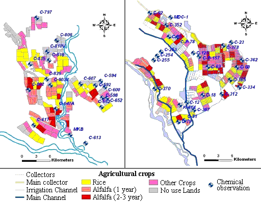
Location of sampling boreholes in Bakhbakty and Bakanass areas is presented in Figures.
 |
| Location of sampling points at the Bakanass (a) and Bakhbakhty (b) areas |
 |
| Geographic location (a) and a schematic map (b) of the study area |
The samples were analyzed for their pH, EC, TDS, concentrations of the major elements: Cl, SO4, Br, NO3, HCO3, Na, K, Ca, Mg, PO4, stable isotopes, and trace elements such as: Al, B, Ba, Cd, Co, Cr, Cu, Fe, Mn, Mo, Ni, Pb, Se, Si, Sn, Sr, Ti, V, Zn, Li, Ag, As, Sb, and Hg (concentrations of trace elements are quite small, and therefore not presented in this report). The total dissolved solids (TDS) in the collected samples at the Bakhbakhty part of the irrigation system ranged from 218 to 2028 mg/l and the mean value was 695 mg/l. The TDS in the samples, collected at the Bakanass part of the irrigation system, ranged from 166 to 969 mg/l and the mean value was 505 mg/l.
 |
|
 |
|||||||||
Previous |
Next |