1. Reverse tasks solution results | |
2. Prognosis task solution results |
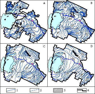
The inverse problems have been solved with the purpose to calibrate the model as well as to study the hydrogeological conditions of the region, which exist within the undisturbed period and the period of 1989. In the process of the inverse problem solution filtration parameters of main aquiferous complexes and low-permeable layers separating them, groundwaters feeding and discharge have been fitted. The quality of the inverse problem solution has been estimated according to the matching of hydroisohypses built based on actual data with the simulated ones.
|
Combined maps of hydroisohypses of aquifers:
a - Paleogenic-Neogenic-Quarternary, b - UpperTuronian-Senonian, c -Upper Albian -Cenomanian, d - Lower-Middle-Albian- Jurassic. Hydroisohypses, meters: 1- produced by true data, 2 - produced by the results of simulation, 3 - regions of absence of aquiferous complexes. Coastal line of Aral sea as of state on: 4 - 1961, 5 - 1989.
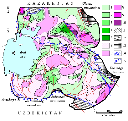
Results of the inverse problem solution, obtained from the model, allowed performing the quantitative estimation of infiltration feeding and discharge of the groundwaters. The feeding moduli of the Paleogene-Neogene-Quaternary aquiferous complex vary from 10 to 100 cubic metres/day * square km. The maximum values of infiltration feeding are related to the Karatau Mountains foothills, the minimal ones – to the sandy massives.
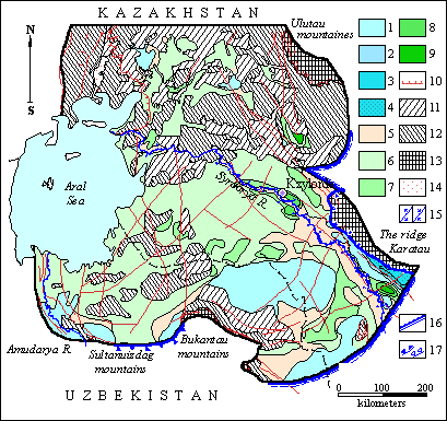 |
Schematic map of modules of infiltration recharge and groundwaters decharge of Paleogenic-Neogenic-Quaternary aquiferous complex of Eastern Priaralye
Recharge modules, cubic m/day, square km: 1 – 0-10; 2 - 10-20; 3 – 20-50; 4 – 50-100. 5 – Zero module (transition). Decharge modules, cubic m /day, square km: 6 – 0-10; 7 – 10-20; 8 – 20-50; 9 – 50-100; 10 - contour of distribution of Paleogenic aquiferous complex ; 11 - distribution of sporadically flooded Neogenic-Quaternary depositions; 2 - absence of aquiferous complex of Neogenic-Quaterary depositions. Outcrops of depositions onto day surface: 13 - that of Paleozoic, 14 - Paleogenic; 15 - Interconnection of the river with groundwaters: a) - recharges, b) - drains, 16 - boundary conditions of the first order; 17 - boundary conditions of the second order: a)-trend of interconnection of groundwaters with Paleozoic framework, b - inflow at the contact of unconsolidated detrital depositions with Paleozoic setting
Evaporation intensity varies from 20-50 cubic metres/day * square km in the streamside of lower flow of the Syr-Darya River and in the Eastern Kyzylkum, to 50-100 cubic metres/day * square km in the area of the Aryskum and the Chushkakol depressions. Here the groundwaters occur close to the surface or taper out. Schematic map of the groundwaters generation of the Paleogene-Neogene-Quaternary aquiferous complex, built based on the data of the inverse stationary problem solution as of 1960-1965, is illustrated on Figure below.
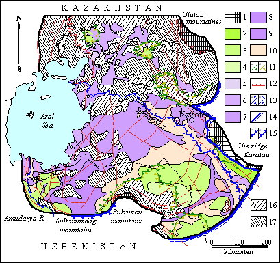 |
Schematic map of groundwaters formation of Paleogenic-Neogenic-Quaternary aquiferous complex of Eastern Priaralye
Regions of groundwater formation sink: 1 - deep infiltration (outcrop of Paleozoic depositions onto day surface), 2 - recharges of surface waters and atmospheric precipitations (Before-mountain zone), 3-4 - infiltration of atmospheric precipitations into sand massives (3 - formation of fresh water lenses with mineralization up to 1 g/l, 4 - with mieralization 1-3 g/l). Regions of decharge of groundwaters: 5 - groundwaters outflow onto day surface, 6 - total evaporation from the level of groundwaters with elevation depths up to 5 m, 7-8 - intraground evaporation from the level of groundwaters with elevation depth (7 - 5-15 m, 8 - >15 m), 9 - by the way of desuccion (brushwoods of saxaul/Haloxylon/); 10 - regions of transition of groundwaters; 11 – ŕ)Recharge contour of Neogenic-Quaternary aquiferous complex at the expense of leakage from below-situated Cretaceous aquiferous complex, á) - contour of decharge of aquiferous complex by the way of leakage into below-situated complex; 12 - contour of distribution of Paleonic aquiferous complex (saxaul suite); 13 - interconnection of groundwaters and surface waters (river: a - recharges, b – drains); 14 - boundary conditions of the first order; 15 - boundary conditions of the second order: a - trend of interconnection of groundwaters with neighbouring territory, b - inflow from the side of Paleozoic framework; 16 - distribution of sporadically flooded Neogenic-Quaternary depositions; 17 - absence of aquiferous complex of Neogenic-Quaternary depositions
Infiltration feeding of the groundwaters of the Upper Turonian-Senonian sediments is realized on the areas of these sediments outcrops. The feeding moduli on these areas comprise 10-100 cubic metres/day * square km.
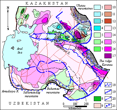 |
Schematic map of groundwaters formation of aquiferous complex of Upper-Turon-Senonic depositions (as of the state for the year 1960) of Eastern Priaralye
Fields of recharge of water-bearing complex. Fields of formation of groundwaters recharge at the expense of absorption of surface waters and atmospheric precipitation on the areas of outcrop of Paleogen onto day surface. Modules, cubic m/day square km: 1 – 0-10, 2 – 10-20, 3 – 20-50, 4 – 50-100. Recharge of water-bearing complex at the expense of overflow from water-bearing complex of Neogen-Quarter-nary depositions. Modules, cubic m/day square km: 5 – 0-2, 6 – 2-4, 7 – 4-10, 8 – 10-20; Fields of transit and decharge of groundwaters. Fields of decharge by evaporation on the areas of outcrop of depositions onto day surface. Modules, cubic m/day square km: 9 – 0-10, 10 – 10-20, 11 – 20-50, 12 – 50-100. Decharge of groundwaters of water-bearing complex of Upper-Turon-Cenonic depositions by overflow into Neogen-Quarternary depositions. Modules, cubic m/day square km: 13 – 0-2, 14 – 2-4, 15 – 4-10, 16 – 10-20, 17 – 20-50; 18 - outer borderline conditions: a - outflow through fracture out of the limits of the territory (boundaries of the second order); b - inflow through fracture from the neighbouring territory (boundaries of the second order); 19 - open boundaries (of the first order); 20 - boundary among balance zones; 21 - inner borderline conditions (second order), fracture and decharge into it
Evaporation from the groundwaters surface can be noticed at the left flank of the Lower-Syr-Darya upheaval along the insignificant areas of the Cretaceous sediments outcrops nearby the Aryskym basin. Evaporation intensity here comprises 20-50 cubic metres/day * square km. Forming of the groundwaters resources of the Upper Turonian-Senonian sediments is realized mainly due to the flowing through low-permeable thicknesses of relative waterproof layers. Areas, where the flow-over occurs from the Neogene-Quaternary complex to the Upper Turonian-Senonian complex, are insignificant. These are the Karatau foothills, Southern part of the Eastern Kyzylkum, the Northern Kyzylkum, individual areas in North-Western part of the investigated territory. Flow-over moduli vary from 10 to 20 cubic metres/day * square km. The rest of the territory represents the discharge zone of the Cretaceous complex groundwaters. Its intensity is different in area extent. It is determined by the lithology of low-permeable sediments, their thicknesses and head gradient. Increasing of flow-over moduli from the Cretaceous complex to the Neogene-Quaternary complex is specific for elevated territories, where they reach 4-10 cubic metres/day * square km. On the rest of the territory the flow-over moduli don't exceed 2 cubic metres/day * square km.
Details of the groundwaters forming of the Upper Albian-Cenomanian aquiferous complex during the undisturbed period (as of 1960) are illustrated on Figure.
 |
Schematic map of formation of groundwaters of aquiferous complex of Upper-Albian-Cenomanic depositions of Eastern Priaralye
Recharge of water-bearing complex at the expense of overflow through confining bed of depositions of Lower-Turon-Senonic depositions (on the areas of outcropinfiltration recharge). Modules, cubic m/day square km: 1 – 0-2, 2 – 2-4, 3 – 4-10, 4 – 10-20, 5 – 20-50. Decharge of groundwateras of water-bearing complex by overflow through confining bed of depositions of Lower-Turon age into superincumbent depositions (on the areas of outcrop - evaporation). Modules, cubic m/day square km: 6 – 0-2, 7 – 2-4, 8 – 4-10, 9 - 10-20, 10 – 20-50; 11 - absence of aquiferous complex; 12 - outcrops of aquiferous complex onto day surface; 13 - fields of formation of groundwaters sink of deep infiltration (outcrop of Paleozoic depositions onto day surface); 14 - outer borderline conditions: a - outlow through fracture beyond the territory (boundary of the second order), b - inflow through fracture from neighbouring territory (boundary of the second order); 15 - inner borderline conditions (second order)
The balance calculations, executed on the model, demonstrate that the main item of the groundwaters forming of the Paleogene-Neogene-Quaternary aquiferous complex in natural conditions is the flow-over from the underlying Upper Turonian-Senonian complex (11.1 cubic metres/s) and infiltration feeding (5.6 cubic metres/s). 2.7 cubic metres/s are received from the external boundaries and approximately 1.5 cubic metres/s are formed due to the losses of the Syr-Darya River waters. The groundwaters of the Paleogene-Neogene-Quaternary aquiferous complex are discharged mainly by evaporation (15.3 cubic metres/s) with flow-over to the Cretaceous aquiferous complexes (1.3 cubic metres/s) and drainage by the Syr-Darya River (1.1 cubic metres/s). Areal discharge through the bottom of the Aral Sea comprises 0.8 cubic metres/s [Veselov V.V., Mirlas V.M., Panichkin V.Yu., 1991].
 |
 |
Analyzing the total balance of the groundwaters of the Upper Turonian-Senonian aquiferous complex we can conclude that the main factor of their resources forming in natural conditions is the flow-over from the underlying Upper Albian-Cenomanian aquiferous complex (7.4 cubic metres/s) as well as the inflows from the external boundaries (9.0 cubic metres/s). On some local areas the infiltration took part in their forming, which total value has comprised 4.8 cubic metres/s. The flow-over from the top was insignificant and comprised the minor value – 1.3 cubic metres/s. At the same time the groundwaters flow-out occurred mainly due to the flow-over to the upper aquiferous complex (11.1 cubic metres/s). Discharge to the Aral Sea has comprised 1.2 cubic metres/s.
In the result of the groundwaters balance structure analysis, calculated based on the model for undisturbed period, it can be stated that:
During the inverse non-stationary (epignosis) problem solution basing on the model, the values of elastic and gravity water yield' factors have been searched. At the same time the operation of waterworks and well-springs was reproduced for the period from 1961 to 1989, as well as the Aral Sea water drawdown from 53 to 39 m, its coastal line reliction.
The technogenic factors intensification, described in section “Ńhanges in hydrogeological conditions, resulted from the technogenic impact”, has led to the groundwaters level drawdown and changing of their balance in all aquiferous complexes. As of end of 1989 the water withdrawal has comprised 1.4 cubic metres/s for the Paleogene-Neogene-Quaternary aquiferous complex. The groundwaters discharge to the Aral Sea significantly increased (from 0.8 cubic metres/s to 2.9 cubic metres/s) due to the high rate of sea level dropdown comparing to the heads drawdown in the Paleogene aquifers.
By 1989 the water withdrawal from the Upper Turonian-Senonian aquiferous complex reached 2.8 cubic metres/s. The total consumption from ownerless well-springs has comprised 1.7 cubic metres/s. The complex' groundwaters discharge to the Aral Sea increased on 0.6 cubic metres/s comparing to the undisturbed conditions and comprised approximately 1.8 cubic metres/s. The flow-out to the neighboring horizons has reduced. The total of balance input items increased (from 22.3 to 25.1 cubic metres/s) due to the flow-over from the underlying and upper-lying aquiferous complexes.
The prognosis of the hydrogeological conditions variation within the simulated territory has been performed for 50 years period. Two versions of calculations have been executed: first – under the condition of water wells productivity preservation as of 1989; second – under consideration of water withdrawals within the limits of approved reserves (according to the sum of categories) as well as waterworks operations as of 1989 on unapproved reserves.
According to the first prognosis version the groundwaters level dropdown will happen by the end of 2039 in all complexes. In the Paleogene-Neogene-Quaternary – 3-5 m in average (Fig.72), in the Upper Turonian-Senonian and Upper Albian-Cenomanian – 5-15 m.
Pressure dropdown in some waterworks will reach 40 m, though not exceeding the allowable value. Therefore, the water withdrawal at the level of 1989 is ensured. The heads dropdown will mainly occur in the central part of the territory. At the same time within the small area, which covers the middle stream of the Syr-Darya River, the alternation of flow-over direction will be noticed and the Paleogene-Neogene-Quaternary aquiferous complex here will start to feed the Cretaceous aquifers. The difference in the head ratio between these complexes will reach 3-5 m. Flow-over module will comprise approximately 2 cubic metres/day * square km. On the rest of the territory, where the flow-over direction between the Upper Turonian-Senonian and the Paleogene-Neogene-Quaternary aquiferous complexes will remain the same, the flow-over intensity will reduce. Head ratio between the Upper Turonian-Senonian and the Lower-Middle Albian-Jurassic aquiferous complexes actually will not change. The value of the groundwaters level dropdown in the Lower-Middle Albian-Jurassic aquiferous complex will not exceed 5 m. The maximum dropdowns will be noticed in the central part of the investigated territory.
As a result of flow-over direction alternation between the Paleogene-Neogene-Quaternary and the Cretaceous aquiferous complexes we should expect the quality deterioration of the groundwaters of the Upper-Cretaceous deposits, because the upper aquiferous complex contains the saline groundwaters (up to 30-50 g/l and more). Analysis of well-spring operation allows making the conclusion that within the period from 1960 till 1989 the area reduction happened and correspondingly in the central part of the territory the isolines of zero overpressure relocated in 10-50 km, and 50-60 km in the Southern Priaralye comparing to the undisturbed conditions. In case of the water withdrawal preservation at the level of year 1989, by year 2039 in the central part of the territory the further area reduction and this line relocation on the same value will occur; then the well-springs operation should be expected. However, in the Southern Priaralye the well-spring will start to restore, because by year 1989 almost all water withdrawals, exploiting the Cretaceous complex, had been shut down. The total value of well-springs consumptions generally for the entire aquiferous complex will reduce down to 0.4 cubic metres/s by year 2039 and will comprise 1.3 cubic metres/s. The value of damage to the surface flow will be insignificant. The discharge of the groundwaters of the first below the surface aquiferous complex to the Aral Sea will drop to 2.3 cubic metres/s due to the heads drawdown of the groundwaters in Paleogene sediments. On the contrary in the Cretaceous aquiferous complex it will increase from 1.8 cubic metres/s to 2 cubic metres/s [Veselov V.V., Spivak L.F., 1997].
During the prognosis problem solution according to the second version it was necessary to simulate the significant water withdrawal increase up to 32.2 cubic metres/s, including up to 10.0 cubic metres/s for the Paleogene-Neogene-Quaternary aquiferous complex, and 22.7 cubic metres/s for the Cretaceous aquiferous complex. By the end of the prognosis period the total well-springs consumption will reduce down to 0.5 cubic metres/s, the head drawdown will occur in all aquiferous complexes. For the upper aquiferous complex the regional level dropdown will comprise approximately 3 m, and 5-10 and more in the Prikaratau part of the territory. These dropdowns will be less than the allowable ones, except for the area of Kyzyl-Orda City. Here they will be comparable with the allowable ones. The head drawdown will occur almost everywhere in the aquiferous complexes of the Cretaceous sediments. At the individual waterworks it will reach 60-80 m, however remaining within the limits of allowable value.
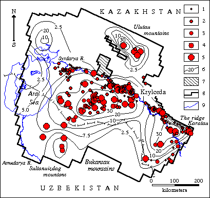 |
Map of predicted depressions of the groundwaters levels of Upper-Turon- Senonian aquiferous complex (as of state on 2040)
Exploitation resources of deposits of groundwaters in sum of categories and productivity of water intakes, working on non-approved reserves (liter/sec): 1- from 1 to 10, 2 - from 10 to 30, 3 - from 30 to 50, 4 - from 50 to 100, 5- more than 100. 6 - isolines of predicted depressions; 7 - regions of absence of aquiferous complex; 8 - simulation region boundary. Coastal line of Aral sea as of state on: 9 - 1961; 10 - 1989
Head ratio changing will result in alternation of the flow-over direction. In the Eastern Priaralye it will probably lead to the quality change of the groundwaters of the Cretaceous aquiferous complex. We should expect the significant changing in the balance structure of the groundwaters. The areas of the groundwaters discharge areas from the Cretaceous to the Paleogene-Neogene-Quaternary aquiferous complex will reduce significantly. At the same time the discharge will increase from the underlying Cretaceous aquiferous complexes to the Upper Turonian-Senonian aquiferous complex. For the Paleogene-Neogene-Quaternary aquiferous complex the evaporation value will reduce, and flow-over from it to the Cretaceous aquiferous complex will increase significantly, the flow-out along the external borders will decrease. Total discharge of the groundwaters to the Aral Sea will drop to 2.6 cubic metres/s. In this connection the salt import by the groundwaters to the offshore water will probably reduce.
The simulation results confirmed the technical possibility of the groundwaters extraction in the amounts of approved reserves according to the category sum. However, the aspect of the groundwaters' massive extraction influence to their quality as well as to the environment condition is not finally clear. The conclusion has been made, that the solution of these problems is possible only with the help of more detailed models, which are reasonable to create for individual areas of the territory investigated.
 |
|
 |
|||||||||
Previous |
Next |