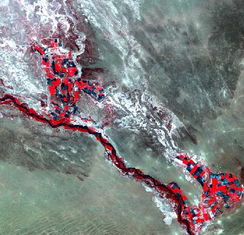
May 26, 1990.
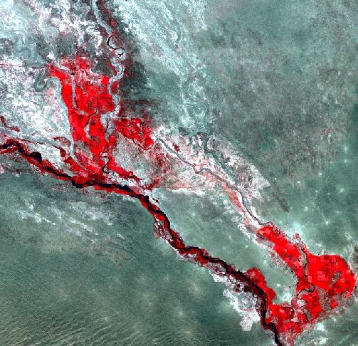
September 3, 2010.
Geologically, the Akdalinsk irrigation area is located in a region of alluvium-proluvium and lake-alluvium sand deposits which lie upon an effectively impermeable, Neogene clay (the Ili Suite). The thickness of the sedimentary deposit ranges from 220 to 250 m, the greatest thickness being found in parts of the estuarine region of the Bakanas Delta. [V.V.Veselov, A.G.Begaliev, N.M.Zakharova and I.N.Gale. Water Resources of the Ily-Balkhash Basin, Kazakhstan //British Geological Survey. Technical report WD/96/47. Hydrogeology series. 1996]
The sands are generally covered by loam and loam-sand sediments with thickness from 0 to 5 m. However, these superficial deposits are not continuous: in parts, mainly in buried, ancient river-channels (Bakanas), the sand formation outcrops at the surface. Groundwater occurs in the sand strata and there is a regional groundwater flow to the north-west towards Lake Balkhash. The sand was deposited during the Upper Pliocene and Quaternary periods.
From the lateral and vertical distribution of groundwaters, seven aquifers can be identified in the South-Pribalkhash artesian basin, but for the purposes of abstraction, only the upper one is of importance. Three water-bearing layers which form a single confined aquifer do not have well-defined boundaries or confining beds between them. They are made up of Horgos, Quaternary and modern sediments and hydraulically connected with each other to form a single groundwater flow regime.
Lithologically, these aquifers consist mainly of fine-grained and mixed-grain sized sands with some gravel and pebbles. There are a few layers and lenses of clayey material, (Figure 3.3). Pumping test results indicate that the mean-weighted coefficient of hydraulic conductivity of the upper 20 m of sand (ignoring the surface loam deposits) is about 16 m/day and transmissivity ranges from 600 to 1,900 m 2/day. It is more difficult to select appropriate hydraulic conductivity parameters for the deeper sand layers to be used by the AROM simulation. The values of hydraulic conductivity coefficient obtained by experimental pumping tests range from 2 to 18 m/day, according to the mechanical composition of the deposits. Based on the available data, the average value for the whole 250 m thickness of sand sediments has been calculated as 6.2 m/day.
The groundwater level prior to irrigation season ranged from 1 to 3 m in the flood-plain of the Ili River and from 8 to 10 m in the remaining area. During the irrigation season, the groundwater level has been changed from 2.0 to 4.5 m because of the continuous aquifer recharge which results from the infiltration of irrigation water.
Presently a quasi steady-state groundwater regime has been formed over practically all the territory of the Akdalinsk irrigation area. The water-table has stabilized and the level is mainly determined by the depth of the collector-drainage network and aquifer parameters.
Data of the satellite LANDSAT from May, 1990 and September, 2010 were used for salted soils area estimation of the aeration zone of the territories near Akdalinski irrigation massive.
Satellite images' characteristics:
| N | Date | Description |
| 1. | 1990-05-26 | Landsat 5, path 150, row 29, zone 43 |
| 2. | 2010-03-09 | Landsat 7, path 150, row 29, zone 43 |
Archival topography data, depths of bedding of groundwaters, information on their mineralization etc. were also used for decoding of satellite images.
The study area was subset from the LANDSAT satellite images. Canales No. 2, 3 and 4 were used for the soils near the Akdalinsky irrigation area salinization dynamic assessment and color image synthesis. When RGB:4,3,2 were chosen, the salted soils areas were visible as the most contrasting .
|
|
| Satellite image of Akdalinsky irrigation area made on May 26, 1990. |
Satellite image of Akdalinsky irrigation area made on September 3, 2010. |
ERDAS IMAGINE supervised classification methodological apparatus has been used for the analysis of the satellite images for the image classification.
Multispectral classification is the process of sorting pixels into a finite number of individual classes, or categories of data, based on their data file values. If a pixel satisfies a certain set of criteria, the pixel is assigned to the class that corresponds to that criterion.
On the basis of field investigations small areas – signatures and even separate pixels, were isolated on the cosmic pictures and those areas can be identified with chosen types and used at the training sites.
| Testing points’ location |
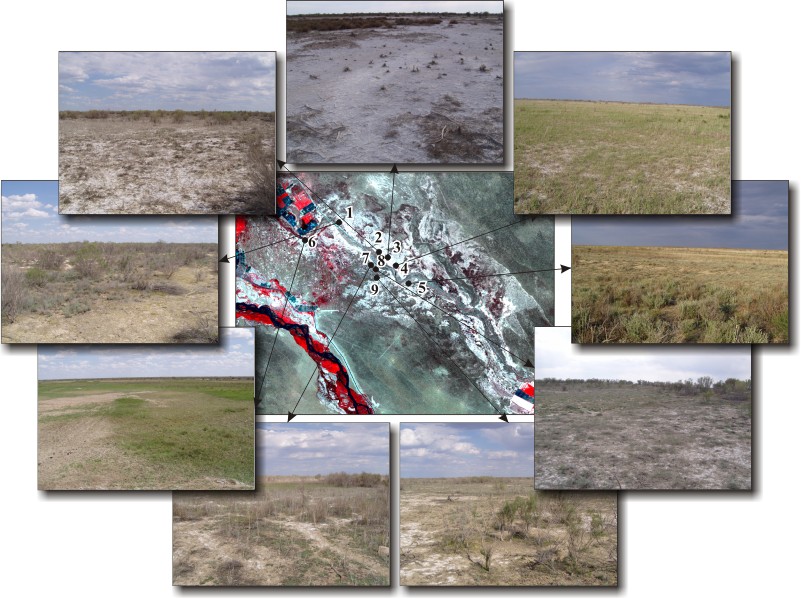 |
| Digits in the picture: 1 – takyr, 2, 3, 8 – solonchak, 4, 5, 6, 7, 9 – vegetated sands |
There were selected five classes:
- salty crust, solonchaks;
- clay desert, takyr;
- vegetated sands;
- bush;
- dense natural vegetation.
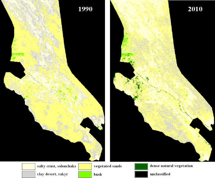
Temporal periods between pictures used – 20 years. To the year of 2010 on the investigated territory takyr and saline soils area increase was observed both on irrigated and on adjoining to them territories.
| Satellite images classification results |
 |
| The results of analysis of changes in areas occupied by selected classes |
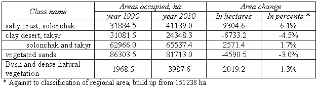 |
Area of solonchaks was increasing by 6% to the year of 2010 within the investigated territory range. Area of takyrs was decreasing by 5%. Solonchaks substituted the areas earlier occupied by takyrs mainly.
Based on the results of investigation it could be concluded that increase of areas of solonchaks on the territories adjoining to Akdalinski massive evidences about negative environmental impact of the exploited massive.
Conclusions and recommendations
Akdalinski irrigation massive soils salination is connected both with natural and anthropogenic factors. As the specific peculiarity of the investigated area is slight drainage of the territory, presence of the natural foci of ground salination and mineralized groundwaters high evaporation.
Salination degree and lightly-soluble salts in soils in natural conditions are defined here by the processes of regional migration of the salts. Considerable influence onto the processes of soil formation during last decades exerts irrigational-economical activity. Large amounts of irrigational water, connected with cultivation of such hydrophilous culture as rice, have led to groundwaters level rise, which in its turn have activated the evaporation process from soil surface and to accumulation of toxic salts in upper layers both on irrigation massive itself and on adjoining territories as well. Violation of agrotechnology, irrigation regime, crop rotation structure, and unsatisfactory status of irrigational and collecting-drainage systems are considerably aggravating the situation.
For reducing soils salination processes intensity both on the massive itself and also on the territories adjoining to it is necessary:
- to lower unproductive expenditures of irrigational water on the massive irrigated by maintaining recommended irrigational norms, irrigation regime and irrigation technologies improvement;
- to conduct the irrigational network reconstruction with the aim to reduce leakages of irrigation waters;
- to do regular cleaning of collecting-drainage network with maintaining of the designed depth and recommended slopes;
- to conduct the monitoring of the state of the irrigated massive soils and on the territories adjoined;
- to create constantly working mathematical model of Akdalinski irrigational massive with the aim of the regular forecasting of the change of hydrogeological-meliorative conditions, of recommendations development, for selecting of the optimal regime of soils exploitation.
 |
|
 |
|||||||||
Previous |
Next |